
Switzerland didn’t end up neutral, landlocked and weirdly central to everything by coincidence. It was horse-trading, geographic luck and some very stubborn Alpine farmers in 1291 that started it and a roomful of nervous European powers in 1815 that locked it in permanently.
Three Cantons, One Very Useful Mountain Pass
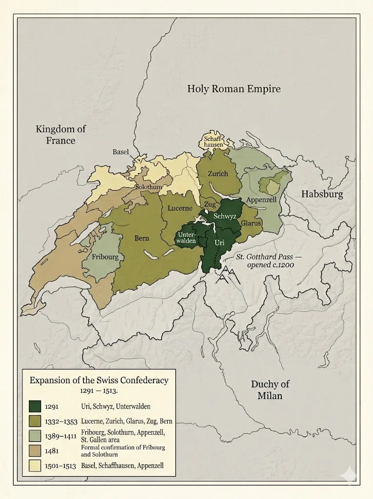
Here’s what doesn’t get said enough about 1291: the founding of Switzerland wasn’t idealistic. Uri, Schwyz and Unterwalden didn’t join hands because they shared a vision. They were scared of the Habsburgs and they controlled something valuable — the St. Gotthard Pass, which had opened around 1200 and immediately became the main artery between northern Europe and Italy. Whoever held that pass held leverage.
So they made a pact. Kept it quiet, kept it local. Called it the Everlasting League — which, credit where it’s due, actually lasted.
By 1353 it was eight cantons. Thirteen by the 1500s. Not explosive growth, but steady. Each addition made geographic sense.
Vienna, 1815 — When Europe Decided Switzerland’s Fate
The Congress of Vienna is usually taught as the moment Europe redrew itself after Napoleon. What gets less attention is the specific conversation about Switzerland — and how bluntly transactional it was.
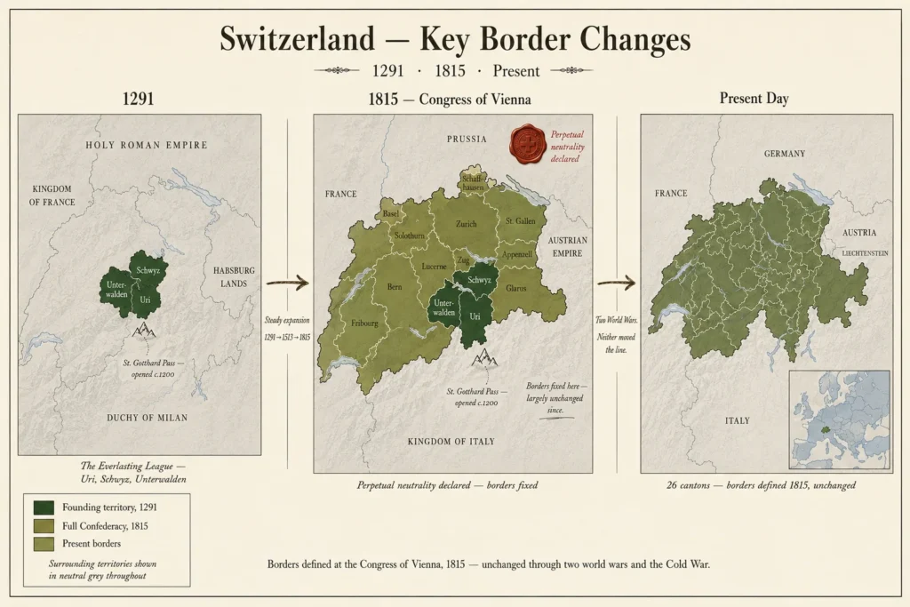
Russia, Britain, Prussia, Austria. None of them particularly sentimental about Swiss independence. But a neutral Switzerland between France and Austria? That was useful. A buffer state costs nothing to maintain if someone else is maintaining it.
So they signed the declaration of perpetual neutrality and drew the borders — borders that have barely shifted since. Switzerland didn’t win it’s neutrality. It was assigned it, because that served everyone else.
Worth sitting with that for a second.
Maps Don’t Lie — But They Do Change
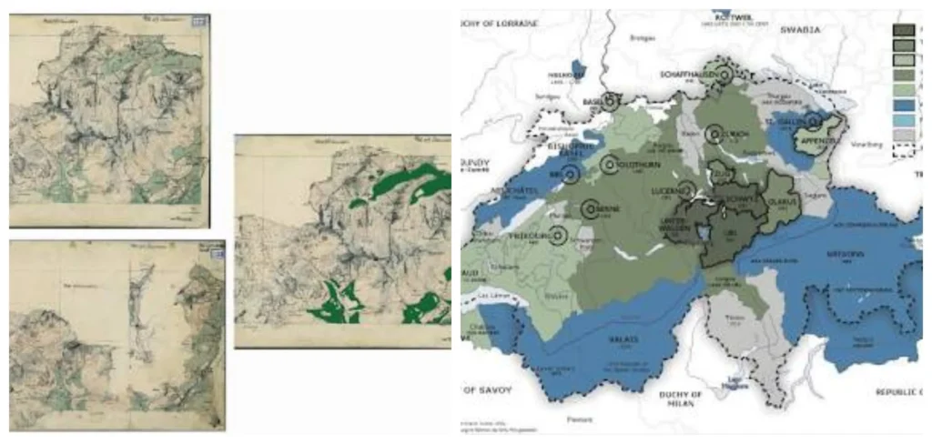
Konrad Türst sat down sometime between 1495 and 1497 and drew the first real map of the Swiss Confederacy. Not perfect — medieval cartography rarely was — but recognizable. You could look at it and see something becoming a country.
The Tabula Nova Heremi Helvetiorum followed in 1513. First printed map. Then Aegidius Tschudi refined things further through the 1500s. Each revision wasn’t just better geography — it was a political statement. Mapping yourself meant claiming yourself.
Then Napoleon showed up and complicated everything.
1798, French invasion. The Helvetic Republic gets imposed — centralized, French-model, deeply unpopular. By 1803 Napoleon himself had to walk it back with the Act of Mediation, reorganizing the country into 19 cantons just to stop the chaos. Funny thing though — that structure, born out of French damage control, basically became modern Switzerland’s skeleton.
It was after this, that the real cartographic stride was made. General, engineer and a fastidiosum, Guillaume-Henri Dufour was the first federal topographical surveyor from 1809 onward. This was truly an historic map, the Dufour Map. Other countries were still surveying land. Dufour was taking the measurement.
Surrounded, Both Times
Both World Wars tested the neutrality doctrine in completely different ways — and neither test was comfortable.
WWI was manageable, relatively. Switzerland mobilized it’s army, accepted refugees, stayed out of the fighting. Tense but workable.
It was a different WWII. By 1940, the whole of Switzerland was surrounded by Axis-controlled territory. All of the neighbouring countries – Germany, Italy, Vichy France, Austria. Ever since, the economic cooperation with Nazi Germany has been subjected to rigorous criticism and this is just as it should be. It took the Bergier Commission several years to untangle it in the 1990s. Under the circumstances, neutrality was not a spotless affair. It was a matter of life and death.
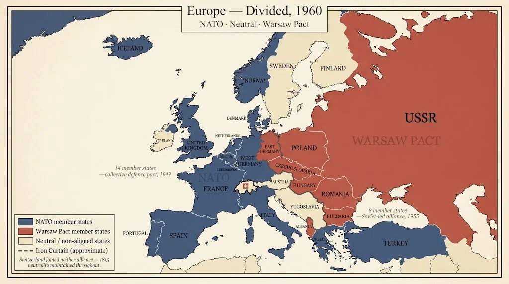
Cold War brought a different kind of pressure. NATO on one side, Warsaw Pact on the other. Switzerland joined neither. Sat precisely between two armed blocs for four decades and somehow made that work as an identity rather than a liability.
The EU Question — Still Unresolved
1992 referendum. The EEA membership has been voted down by the smallest margin ever in Switzerland. Nor did EU membership ever even take off.
What ensued was pragmatic and truly most unusual: more than 120 bilateral agreements with the EU covering trade, movement of persons, research cooperation and more. Economic integration to the fullest extent, no political membership. Much of the access is available to Switzerland, but not to the table where decisions are made.
It’s debatable whether that’s smart and/or sustainable or not. The bilateral framework has been negotiated numerous times and tensions have not abated.
Key Switzerland–EU Bilateral Agreements
| Agreement | Year Signed | Area |
|---|---|---|
| Free Trade Agreement | 1972 | Trade |
| Bilateral I — Free Movement of Persons | 1999 | People |
| Bilateral I — Land Transport | 1999 | Transport |
| Bilateral I — Air Transport | 1999 | Transport |
| Bilateral I — Research Cooperation | 1999 | Research |
| Bilateral I — Technical Barriers to Trade | 1999 | Trade |
| Bilateral I — Public Procurement | 1999 | Trade |
| Bilateral I — Agriculture | 1999 | Trade |
| Schengen/Dublin Association | 2004 | Border/Security |
| Bilateral II — Taxation of Savings | 2004 | Finance |
| Bilateral II — Processed Agricultural Products | 2004 | Trade |
| Bilateral II — Statistics | 2004 | Data |
| Bilateral II — Environment | 2004 | Environment |
| Bilateral II — Media (MEDIA programme) | 2004 | Culture |
| Bilateral II — Education (Bologna) | 2004 | Education |
| Horizon Europe Association | 2024 | Research |