
I will be honest with you, I nearly did not. One of my friends continued telling me that Namibia was not like any other country on the continent and I continued nodding my head and secretly making bookings elsewhere. Then one night I fell down a rabbit hole of photographs and two weeks later I was boarding a flight to Windhoek with no strategy other than a sketchy itinerary and a great deal of curiosity. It was the most successful call I ever made in years of travel.
Namibia inhabits one of the most sparsely populated countries on the planet – an approximate of 2.6 million in an area that is greater than that of both Texas and California. What that translates to ground wise is space. Silence. Sceneries which seem truly untouched. It is the type of a place where you take two-hour drive and meet three other cars.
Windhoek: Your 24 Hours Here Are Worth the Beef
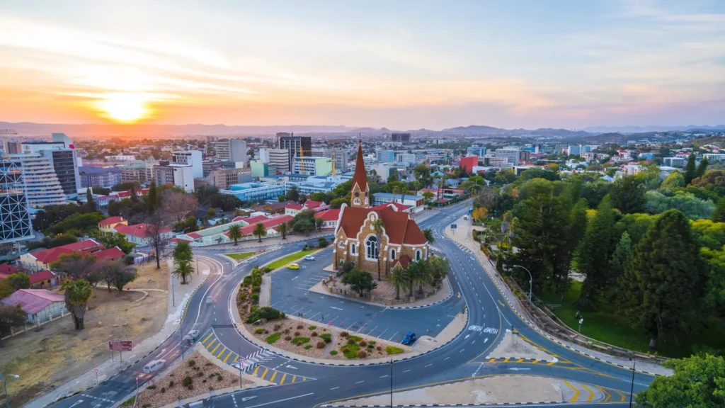
Majority of the people use Windhoek as a transit city. Big mistake. I was here all day long and this day altered my perception of the rest of the country.
The city bears this incongruous, superimposed identity – German colonial building with modern Africa trade right beside it. You will pass an old Lutheran church, which is a hundred years old and make a turn to a street market. The city is anchored by the Christ Church which was constructed in 1907. It is not huge or bombastic but when you are standing there during the sunset and the entire city is lying in the background, there is something about it that you will remember.
What I’d actually recommend doing in Windhoek:
- Start at the Namibia Craft Centre on Independence Avenue — genuine local work, nothing mass-produced.
- Grab breakfast at The Stellenbosch Wine Bar & Restaurant — the eggs benedict with kudu sausage is absurd in the best way.
- Walk through Klein Windhoek in the early morning before it gets hot.
- The National Museum of Namibia covers the country’s history honestly, including the 1904 Herero and Nama genocide — don’t skip this.
(📸 Place image: Windhoek street-level photo — Image 19)
Something I found surprising: the city is actually safe to walk at daytime. It’s energy differs compared to that of Johannesburg or Lagos – it is slower, quieter and easier to manage. Hire your 4×4 at this place and then head south or north. You shall need it in other places.
Sossusvlei and Big Daddy: The Dunes Don’t Look Real Until You’re On Them
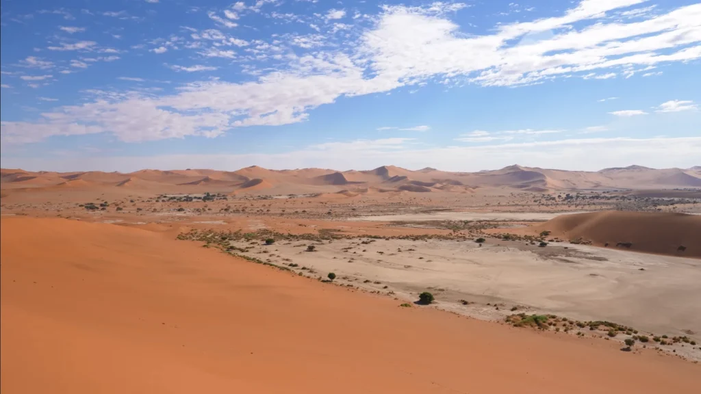
Nothing prepares you for the color. I’ve seen desert in Morocco, in Jordan, in the American southwest. Sossusvlei is different. The sand here has been oxidizing for somewhere between 5 and 55 million years according to geological research, the iron coating on each grain creates that deep, almost unreal orange-red. The older the dune, the more saturated the color.
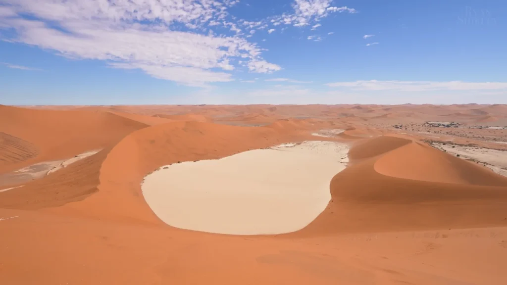
Big Daddy is the tallest dune in the area at roughly 325 meters. I climbed it. It took about 45 minutes going up and maybe 8 minutes sliding back down on foot. The view from the ridge and I say this as someone who doesn’t throw this word around is genuinely staggering.
A few things I wish someone had told me:
| Tip | Why It Matters |
| Leave your lodge before 5 AM | Gate opens at sunrise; dunes fill up fast |
| Bring more water than you think | Humidity is near zero — dehydration sneaks up on you |
| Wear closed shoes | Sand can hit 70°C on the surface by mid-morning |
| Come back at golden hour if possible | The color shift between 5–6 PM is something else entirely |
It is believed that the Namib Desert is the oldest desert on earth estimated to be between 55 and 80 million years old. Being on top of Big Daddy and realizing that the sand that I stand on is older than most mountain ranges, that is a thought that will take some time to sink in.
Deadvlei: The Most Photographed Place in Namibia (For Good Reason)
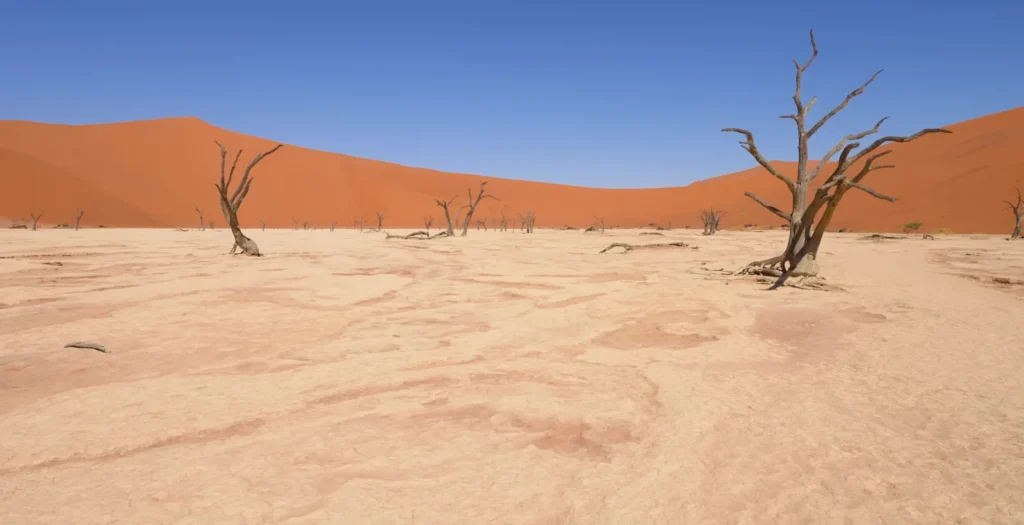
It is the Deadvlei that makes it weird and that is approximately 40 minutes walkable distance on the Sossusvlei parking area. This is due to the white clay pan that obscures white on orange and is punctuated with dead camel thorn trees, which stopped growing around 900 years ago when moving dunes blocked the floodwaters of the Tsauchab River. The trees never decayed as it is too dry. They just… stayed. Black, skeletal, preserved.

There’s no shade. No sound except wind. The light is reflected on the clay floor and illuminates all that is underneath. Photographers are literally crazed at this place and I am not faulting the photographers. The reason is that I sat in the middle of it and was almost 20 minutes without taking any photo, which, in my case, speaks volumes.
It is also worth marking the walk: it is through soft sand and can be vicious in the heat. I ventured out at 7 AM and it was 30 o C. Majority of guides recommend that one should visit as early as possible, prior to 9 AM. Then the distortion of photographs by heat is anyway bad.
What you’re actually looking at when you stand in Deadvlei:
- A clay pan formed by ancient floods from the Tsauchab River.
- Dead camel thorn trees (Vachellia erioloba) dating back roughly 900 years.
- Dune Big Daddy visible on the left ridge.
- Surrounding dunes reaching up to 200 meters in height.
- Complete absence of decomposition — no fungi can survive the aridity.
It’s the kind of place where you take 300 photos and then realize none of them quite got it. That’s either a failure of photography or proof that you had to be there. Probably the second one.
Etosha National Park: The Waterhole That Changed How I Think About Wildlife
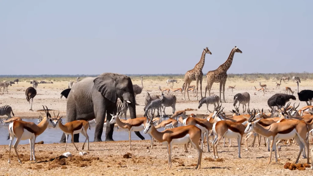
I’ve done safaris. Kenya, Tanzania, Botswana the whole circuit. Etosha operates on a completely different logic. Everywhere else, you chase the animals. Here, you sit at a waterhole and wait. And what comes to you is honestly, I struggled to believe what I was watching.
The snapshot I made at Okaukuejo waterhole at about 4 pm: one elephant, two giraffes, a group of zebras and the springbok all over, two ostriches with their odd strutting dance, wildebeest in the background. Everything in the neighborhood of half a mile. No fences between them and me. Only a small wall of stone, a bench and nothing.
Etosha covers a total of about 22,270 square kilometers- the size of Switzerland- and the Etosha Pan, a massive salt pan that can be seen by the eye of a satellite. In dry season (June to October), all of the animals in the area flock to the waterholes since there is just no water anywhere else. And the fact that it is that concentration that makes Etosha unlike anywhere I ever went.
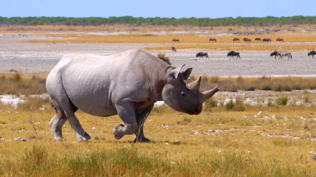
Then there was the rhino.
We were parked approximately 80 meters and one of the black rhinos trotted out of the bush not walking, but rather with intent on the open grassland. The black rhino is highly endangered; there are less than 6,000 left on the planet, with Namibia having the highest population free-roaming of any nation. A man called Thomas, who was my guide and had been doing it 22 years, muttered: Most guides do the whole business and see about a dozen. Four minutes later we saw it sink back into the scrub.
Etosha at a glance — what to know before you go:
| Category | Detail |
| Best time to visit | June – October (dry season, best waterhole action) |
| Self-drive or guided? | Both work — roads are well-maintained gravel |
| Must-stop waterholes | Okaukuejo, Halali, Chudop, Klein Namutoni |
| Night drives | Available from rest camps — black rhino sightings more common after dark |
| Big Five status | Lion, leopard, elephant, rhino present — buffalo absent |
| Park entry fee | Check current rates at Namibia Wildlife Resorts |
One thing I didn’t expect: the birding. Over 340 bird species recorded in Etosha. I’m not a birder by nature but when a crimson-breasted shrike lands two feet from your car window, you start paying attention.
Cape Cross Seal Reserve: Chaotic, Loud and Completely Unforgettable

No one threatens you of the odor. That’s the first thing.
You are some 40 kilometers north of Henties Bay, drifting with a coastal gravel road, where the cold Benguela Current is forcing grey Atlantic water on red desert sand, already an incongruous mix of the two and all of which is suddenly struck by rolling down the window. Part fish, part wet fur and part you can not quite name. You’ve arrived.
One of the biggest Cape fur seal colonies on earth are located at Cape Cross with an estimate of between 80,000 and 100,000 animals depending on the time of year. They’re everywhere. Heaped upon the rocks, reclining on the sand, lying on top of each other in ways which are structurally impossible. Bulls the size of small motorcycles. Pups, born between November and December and scurrying around trying to look confused.
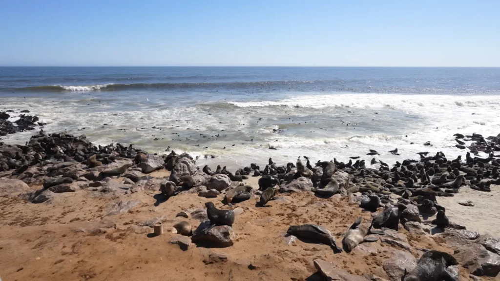
I stood at the edge of the viewing area and a pup maybe three weeks old waddled over and sniffed my boot. I didn’t move for a full two minutes.
The raw numbers here are hard to process:
- Approximately 100,000 seals during season time.
- The colony is some 4 kilometers long along the shore.
- Cape fur seals have the ability to swim as deep as 200 meters and the capacity to breathe in as long as 7 minutes.
- Males that are adults weigh up to 360 kilograms.
- Adult males weigh up to 360 kilograms
- It is fed on by the Benguela Current, one of the richest upwelling systems on earth.
Something nearly compelling about the size of it. Not emphatic wildlife-documentary imbibing. More so -this is what the world used to be like before human beings had said how many animals should be where. Raw. Uncurated. And totally unconcerned about your presence.
The drive back on the coast to Swakopmund, afterwards, the desert hills on one side, the cold grey ocean on the other, is one of my better hours in an automobile.
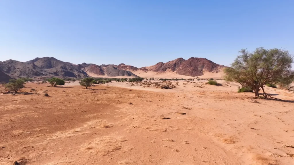
Epupa Falls and Damaraland: The North That Most Tourists Never Reach
Most of the experience is getting to Epupa Falls. The highway north on through Damaraland is rather an adventure in driving than a leisurely meditation – large red plains, outlines of volcanic mountains, the oryx rising here and there on a ridge as though it were put there to be photographed.
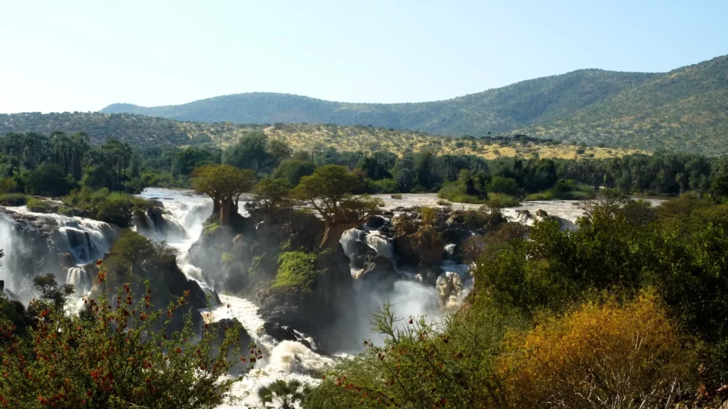
Epupa is located on the Kunene River which is the border of Namibia and Angola. The falls are not dramatic in the Victoria Falls meaning they are broad and divided into several channels over a span of about 500 meters, which fall approximately 60 meters overall. The baobabs are what is strange and beautiful. Sacred, shriveled, trunked baobabs right out of the rock formations between the channels and the roots are clinging to the basalt and the water is on a smashing spree.

I arrived late afternoon when the light was going gold. Sat there for two hours. A local Himba woman was washing clothes in the calmer water upstream, she’d walked this same stretch of river her whole life and watching the falls from where she was standing, I thought about how a place can mean completely different things to different people standing in the same spot.
Damaraland — what this region actually offers:
- It is the home of desert adapted elephants – it’s own unique group of animals that can survive days without consuming water, unlike their savanna counterparts. Monitored and observed by the Desert Elephant Conservation project.
- Twyfelfontein A World Heritage Site of more than 2,500 rock inscriptions created by hunter-gatherers of the San people, some dating to 6,000 years old.
- Brandberg mountain in Namibia, the highest mountain in Namibia, 2,573 meters above sea level, where the renowned White Lady rock painting is found.
- Small Himba communities still living traditionally in this region some offer respectful cultural visits.
- Virtually zero light pollution the night sky here is genuinely otherworldly.
One day during the night, in Damaraland, I just woke at 2 AM without any particular reason and went out of the tent and stood there, standing at least 20 minutes and could do nothing but stare upwards. It was not the smear of a Milky Way, but the wall of light. I’ve seen good night skies. This was different.
Spitzkoppe: Matterhorn, Namibia Nobody Vill Know of It
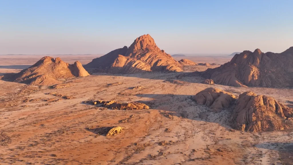
At some point when we are driving towards Spitzkoppe, the rock is on the horizon, the sudden, impossible spike of granite that bursts out of an otherwise completely flat desert terrain 1,728 meters. No buildup. No foothills. Just the plain and then that. It looks photoshopped. It resembles the fact that a mountain is dropped in the wrong position.
The Spitzkoppe massif is approximately 120 million- years-old – a product of volcanic action that left these bare granite domes after all the softer material was eroded away during tens of millions of years. It is geologically known as an inselberg- island mountain. In real life, it is one of the more surreal things I have been next to.
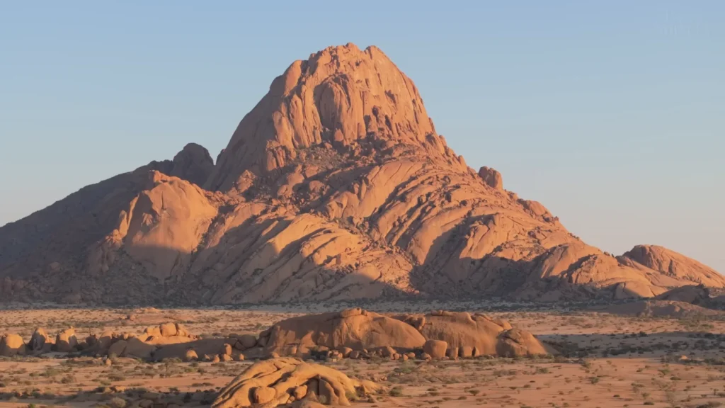
I camped at the base. That is something you can literally do here and the Spitzkoppe Community Campsite is run by the local Damara community and there are various sites scattered amongst the boulders at the base of the main peak. Two house-sized granite slabs were shoved into a space between my tent. Early in the morning, just as the sun struck the rock it gave it this rich amber-orange and the entire massif appeared to be glowing with an internal glow.
What Spitzkoppe does not give us to see:
- Rock climbing – climbing routes of all levels, including easy and difficult technical climbing. The central peak needs guides and permits.
- San Bushman rock art – ancient paintings in deep bases beneath overhangs and in shallow caves, some of which are thought to be more than 2,000 years old.
- Pontok Mountains nearby — a secondary granite cluster worth an afternoon wander.
- Stargazing — zero light pollution and the granite formations create natural frames for the sky.
- Community-run campsite and curio market — buy directly from local Damara craftspeople.
The boulder scrambling around the base takes a half day easily. No technical skill needed, just comfortable shoes and some patience with the heat. I found a shallow cave around 10 AM with San paintings on the ceiling red ochre figures, animals, abstract shapes and sat there alone for 40 minutes. No barriers. No plexiglass. Just the paintings and the silence and the faint smell of ancient rock.
Sandwich Harbour: Where the Desert Runs Straight Into the Ocean

Of everything in Namibia, this is the image I kept trying to explain to people when I got back. A desert proper, towering orange dune desert ending abruptly at the Atlantic Ocean. No beach. No transition. The dune just drops into the water.
Sandwich Harbour is approximately 50 kilometers south of Walvis Bay, where it can be accessed only by 4×4 driving along the beach during low tide. The window is very small and get the time of the tide wrong and you will either be deep in soft sand or be overrun by the water. Before leaving my guide examined the tide charts twice. At that point too, waves were crashing near enough to spray the windscreen.
The Sandwich Harbour wetland itself is a listed Ramsar site – and is internationally recognised as being of significance to migratory birds. Pelicans, cormorants that seem like an outnumbered lot until you get accustomed to what the Namibian coastline really consists of. The dunes at the back of it, then pushing more than 100 meters and there the cold green Atlantic. And it is a clash of two entirely different worlds with the same advantage.
The logistics — because this one requires planning:
| Factor | What to Know |
| Access | 4×4 only — no exceptions, hire a local operator if needed |
| Tide timing | Check Windguru or local guides — window varies daily |
| Best operators | Sandwich Harbour 4×4 (Walvis Bay based) — experienced with the route |
| Photography | Late afternoon light from the dune crests is the shot |
| Wildlife | Flamingo and pelican congregations near the lagoon area |
| Distance from Walvis Bay | Roughly 50 km — allow 3–4 hours return with stops |
I climbed one of the dunes on the eastern edge and sat at the crest. Ocean on one side. Desert stretching inland on the other. It felt genuinely like standing at the seam of two different planets.
Fish River Canyon: Africa’s Grand Canyon and the Person-Sized Detail
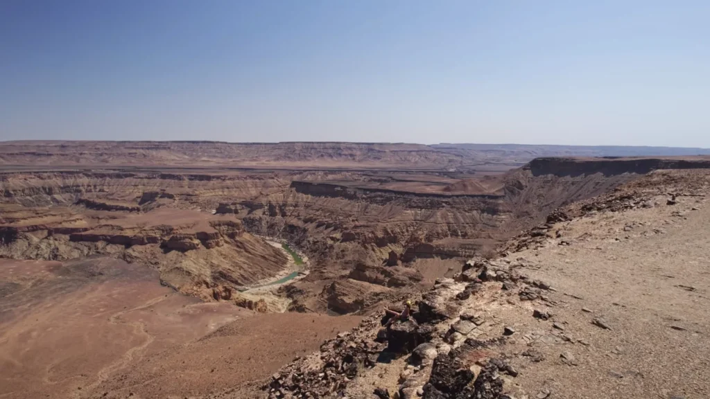
I want to draw your attention to the human figure sitting on the rim in this photograph small, in a yellow jacket, feet probably dangling over 550 meters of air. That’s not a stock shot. That’s how it actually looks when you’re there. You and then an abyss.
The second largest canyon after the Grand Canyon in the world is the Fish River Canyon with a length of about 160 kilometers and a width of up to 27 kilometers and a depth of approximately 550 meters. It is a sculpture created by billions of years of tectonic movements, followed by the slow erosion of the rock by the Fish River. The geology that can be seen on those walls is among the oldest that can be seen on the surface of the planet with some of the parts being approximately 650 million years old.
I drove in from the south, arriving at the main viewpoint in the early afternoon not the ideal light, the canyon floor was in shadow and the haze was heavy. Stayed until sunset. That was the right call. As the light dropped, the layers in the canyon walls started showing their color properly rust, grey, ochre, deep brown and the green thread of the river at the bottom caught the last light.
What to know about Fish River Canyon:
- The Fish River Hiking Trail is 86 kilometers through the canyon floor rated among the toughest multi-day hikes in Africa. Requires a medical certificate and runs May to September only.
- The main viewpoints are accessible by regular car no 4×4 needed for the lookout points.
- Nearby Ai-Ais Hot Springs at the canyon’s southern end thermal baths right at the trail finish. Temperature around 60°C at the source.
- Best photography light: early morning or the last 90 minutes before sunset.
- Closest town is Keetmanshoop fuel up before heading to the canyon.
Honestly, I went expecting to be slightly underwhelmed it’s one of those places that gets compared to something more famous and inevitably suffers for it. It didn’t. It’s it’s own thing entirely. Quieter than the Grand Canyon. More raw. Nobody trying to sell you a helicopter tour.
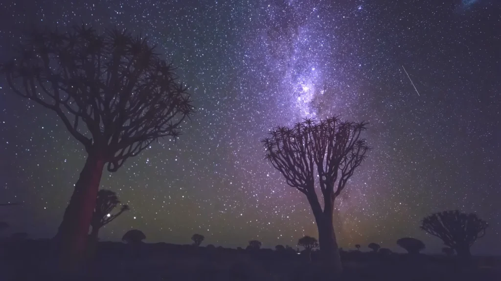
Quiver Tree Forest: The Trees and the Best Night Sky I Ever Saw
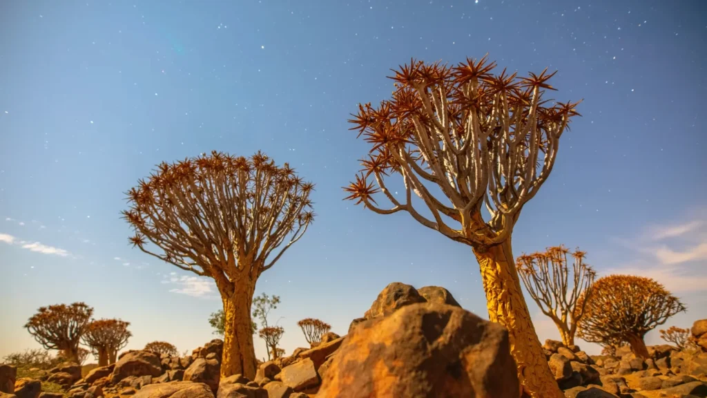
On a rocky hill outside Keetmanshoop, where a visitor would not notice it until the moment he or she is in it, there is a forest of Aloidendron dichotomum -quiver trees. It is named after the San people who used to drill holes through the branches to create quivers to use in their arrows. They grow slowly. A few of the trees here are supposed to be 200300 years old, but appear to be much older.
Here is a conservation issue that should not be overlooked: climate change is forcing the viable range of quiver trees southwards with a steady movement. In studies in journals such as Diversity and Distributions, major die-offs in the north of their distribution have been recorded during the last 20 years. The forest that is in Keetmanshoop could appear permanent. It isn’t, necessarily.
I stayed the night at the Quiver Tree Forest Rest Camp basic chalets, no Wi-Fi, completely dark at night. That darkness is the point. Around 9 PM I walked into the forest with a headlamp switched off and just stood there. The Milky Way was directly overhead, framed between two quiver tree silhouettes. It’s the photograph in Image 13 and even that which is a genuinely great photograph doesn’t fully capture being in it.
Practical Guide: What You Actually Need to Know Before Going
Getting There and Around
The majority of the international flights are based in Windhoek and Hosea Kutako International Airport, with primary connections to Johannesburg, Frankfurt and Dubai. Air Namibia operates on local flights but flights vary – make sure to verify.
Serious travel cannot be done without a 4×4. The big attractions, Sossusvlei, Spitzkoppe, Sandwich Harbour, Damaraland need one or are much more approachable with one. Hire a car in Windhoek and calculate the cost of driving on a gravel road. Good and trustworthy local alternatives are Asco Car Hire and Odyssey Car Hire.
When to Go
| Season | Months | What to Expect |
| Dry season | May – October | Best wildlife, cooler nights, Etosha waterholes at peak |
| Green season | November – April | Lush landscapes, fewer tourists, some roads difficult |
| Peak dune color | Year-round | Morning light June–August most consistent |
| Epupa Falls | March – May | Highest water flow after rains |
Costs — rough ballpark
- Budget travel (camping, self-drive): roughly $80–$120 USD/day
- Mid-range (lodges, guided day trips): roughly $200–$350 USD/day
- High-end (private camps, fly-in safaris): $600+ USD/day
National park fees are handled through Namibia Wildlife Resorts book accommodations inside parks well in advance during peak season.
Health and Safety
- Malaria risk exists in the north (Caprivi Strip, Etosha, Damaraland) — consult CDC travel health guidelines before departure.
- Sun protection is serious business UV index regularly hits extreme levels.
- Water is generally safe in towns; carry extra in remote areas.
A Note on Responsible Travel
Namibia runs one of Africa’s most successful community-based natural resource management programs over 80 communal conservancies covering nearly 20% of the country’s land. When you pay community campsite fees, hire local guides or buy directly from craft markets, that money stays in the conservancy. It’s one of the more functional models of conservation-linked tourism I’ve encountered anywhere.