
Arusha does not appear like a safari town. To be honest I was flying in and I thought this is greener than I thought. Way greener. The city is approximately 1,400 meters above the sea level and the altitude makes the city cooler almost pleasant, something that no one had told me. I’d packed for heat. I was wrong.
The city is just in front of mount meru and you can view it almost anywhere provided the clouds are on your side, which they are not usually. It is one of those things as you are having breakfast and you look up and there is a volcano 4,566 meters high and there it is. Casually existing.
Most northern circuit safaris are centered in Arusha where it is justified that the place is regarded as the operational center. The town per se is a day, not in the sense of something splendid, but of something actual. The clock tower on the Maasai market, chapati when I bought them on a roadside stand and did not spend more than a dollar, the mayhem of dalla-dalla minibuses in which no one seems to be ever hurt. I actually spent another night simply because I was not ready to leave.
A few things worth knowing before you land in Arusha:
- Most of the nationalities allow visa on arrival, where the cost is 50 USD, with crisp bills, the ripped ones are rejected.
- Julius Nyerere and Kilimanjaro International Airport both serve the region; KIA is closer to Arusha.
- The short rains run November–December, long rains March–May — I went in January, near-perfect conditions.
- There is good cell service; the Vodacom and Airtel SIMs are also cheap and sold at the airport.
Kilimanjaro: Six Days up, Eight Hours Down, Zero Regrets

I’ll be straight with you. I almost didn’t summit.
Day five struck me at a level of around 4,800 meters and my body was making a silent protest, my head was aching behind the eyes, my legs were like they were running on a one-second delay. The problem of elevation sickness does not consider the fitness. I spotted a person who had the appearance of those who enjoyed running marathons run round at Barafu Camp. No shame in it. The success rate of the mountain on the Machame Route that I used is approximately 85 percent and it is with due acclimatization days included.

The climb to Uhuru Peak in the middle of the night is a peculiar scene by itself. You are in a trail of headlights, it is either -15 o C and no one is chatting. The sound of just boots crushing ice and the wind that sometimes makes you wonder why you ever made such a decision in life. Then above the cloud layer you have the sky crazed and the stars that I was not aware existed.
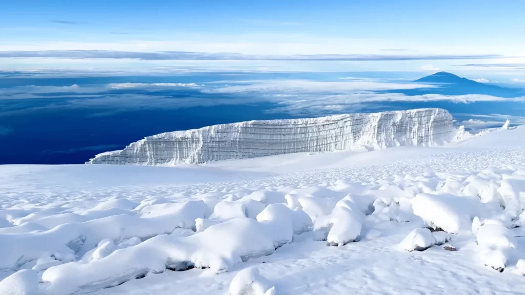
That view from the summit. The glaciers are going — scientists estimate they could vanish entirely by 2040 — so that wall of ancient ice you see in the photo, with Meru floating on the cloud horizon? Go now. Genuinely.
Kilimanjaro Route Comparison
| Route | Duration | Difficulty | Scenery | Success Rate |
| Machame | 6–7 days | Hard | Excellent | ~85% |
| Lemosho | 7–8 days | Moderate-Hard | Best | ~90% |
| Marangu | 5–6 days | Moderate | Good | ~65% |
| Rongai | 6–7 days | Moderate | Good | ~80% |
The Machame pathway, which I followed, climbs the Shira Plateau, downs onto the Barranco Wall (which sounds scarier than it actually should be, but still fills one with fear) and up to the alpine desert area where the groundsels who inhabit it look like they came out of a Dr. Seuss book.
That stream in the photo — I filled my bottle there on day three. The guide looked at me like I was doing something risky. He was probably right.
Mount Meru: The One Everyone Skips (Don’t Skip It)
Meru does not receive the same attention Kilimanjaro does and that is not right and in fact, that is a gift to whoever does it. It is the fifth highest peak of Africa at 4,566 meters. The crater rim walk is truly magnificent and since the path traverses the Arusha National park, you are hiking through the lower-slopes of the park past buffalo and giraffe. Which is strange. Great, but strange.
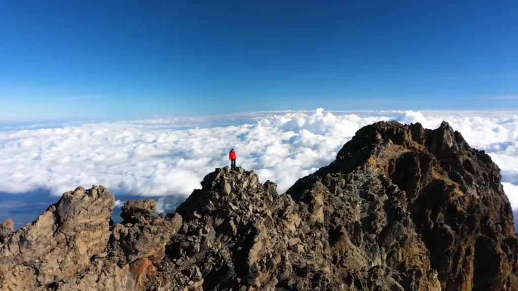
That photo — the person in red standing on the rocky summit ridge with an entire ocean of cloud below — that’s what you earn. And you do it in three to four days, not six or seven. The views of Kilimanjaro from Meru’s summit on a clear morning are better than any drone shot I’ve seen.
What Makes Meru Worth It:
- Far fewer crowds than Kili — I shared the summit crater with four other people.
- Armed ranger accompanies every group due to buffalo encounters on lower slopes.
- Excellent acclimatization prep if you’re planning Kilimanjaro afterward.
- The Momela Lakes below the mountain have flamingos — you see them on the descent.
Napuru Jungle and Arusha National Park: The Hidden Morning I Almost Missed
Nobody told me about Napuru. No exaggeration that, when I inquired of three different people in Arusha on what to do with an extra half-day not one of them mentioned it. I had stumbled upon it almost by chance, when an owner of a guesthouse, who provided me with a sketchy map on a napkin and advised me to go early before the tour buses had discovered it.
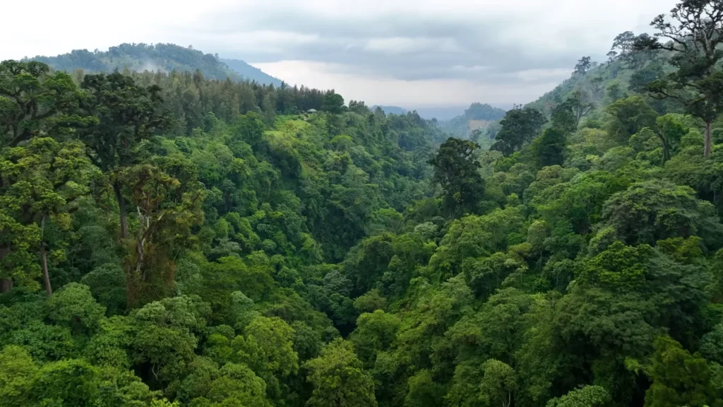
The Arusha National Park is located possibly 25 kilometers east of the city. It is tiny by Tanzanian standards – about 552 square kilometers – but the content it carries is almost unjustified. Montane wood, flamingo ponds, colobus apes, buffalo and then Meru hanging over the entire building.
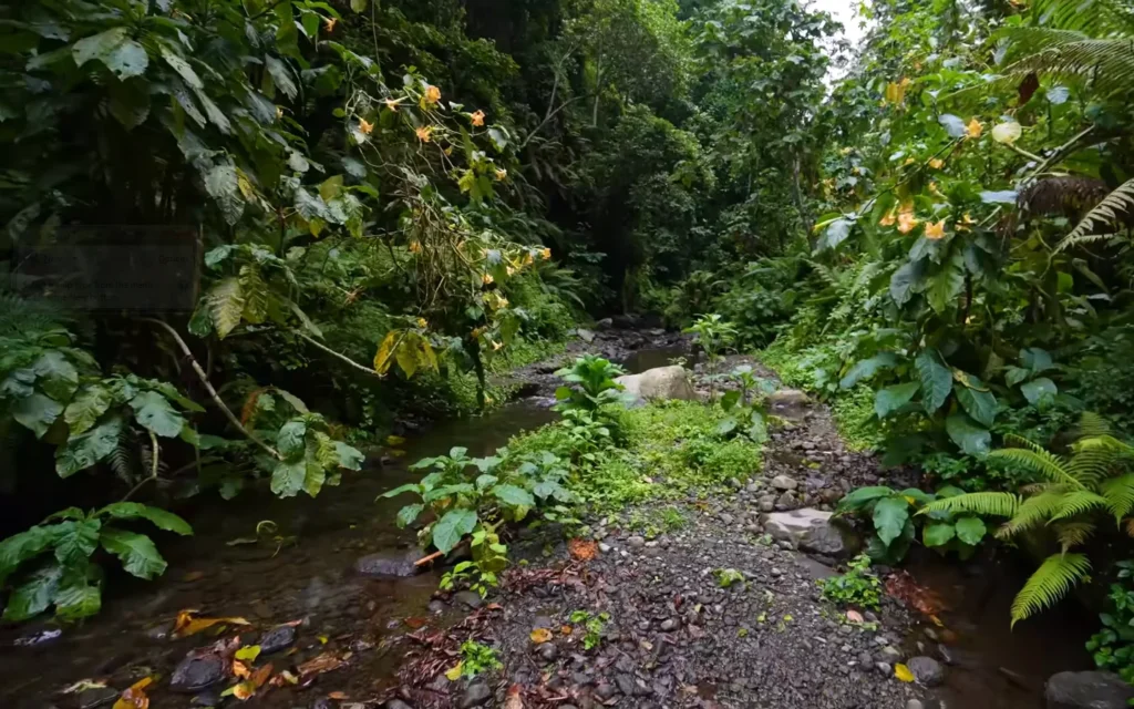
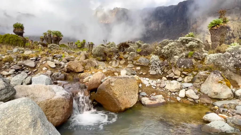
Napuru forest trail was the place that clicked with me. In the picture that stream is icy-cold in January and the orange trumpet flowers suspended over it are Brugmansia, presumably. The trail is rocky, the shrubbery over you shuts and ten minutes later you are totally unaware that you are twenty minutes away in a metropolis. One of the colobus monkeys, a black-and-white one, dashed down the trees somewhere to my left and uttered a sound which momentarily paralyzed my heart.
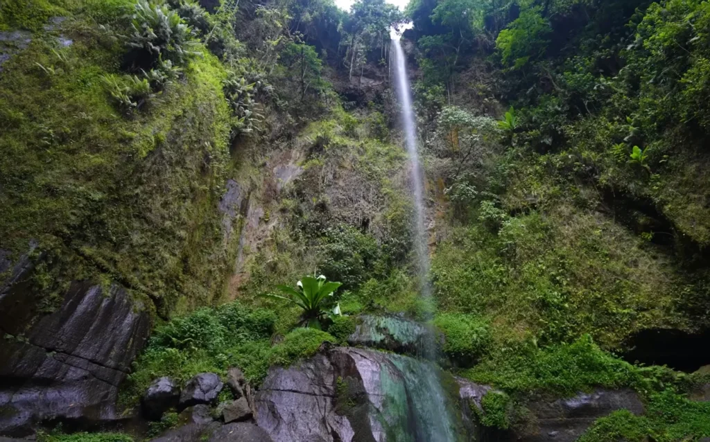
The fall at the trail end – I had not imagined it resembled an enclosure so much. Three sides mossy, the one strand of water falling down perhaps 30 meters up, the ferns growing through the cracks in the face of the rock. It is the sort of place that you are only in longer than you intended, which is okay, since there are no places that you need to go.
Quick Napuru Trail Notes:
- Entry through Arusha National Park gate — fees apply, around $45 USD per person for non-residents.
- Hire a park guide at the gate — not optional for some trails due to buffalo and worth it anyway.
- Trail to the waterfall takes about 90 minutes return at a relaxed pace.
- Best done 7–9am before heat and groups arrive.
- Wear actual shoes — the rocky stream crossings are not sandal-friendly.
Lake Manyara: Where a Lioness Stared at Me From a Tree
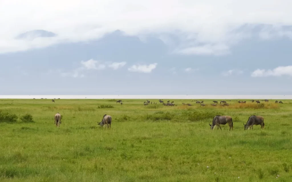
The journey to Lake manyara, which is about two hours, depends on the road, which it did most of the time. You tumble off the escarpment of the Great Rift Valley straight on to this alkaline lake which is spanning the valley floor and glitters silver-grey in the flat light wildebeest grazing the floodplain all the way to the edge of it.
Manyara is not a big place – it is a half-day between Arusha and Ngorongoro and they shouldn’t do it. The forest close to the main gate is a groundwater forest where I have never visited before, but I found it to be one of the most dense and strange. Fig-trees whose roots are big as houses, groups of vervet monkeys infesting every corner, groups of baboons who no longer seem to be frightened of automobiles.
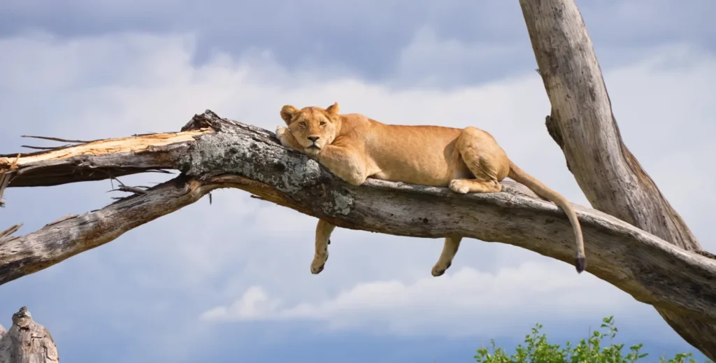
Then that lioness.
She was in a fever tree maybe three meters off the track, just… draped across a branch with her legs hanging down like she’d decided gravity was optional. The guide cut the engine. Nobody spoke. She looked at the vehicle with the profound indifference of someone who has never once felt threatened by anything, then looked away. We sat there for probably eight minutes. I’ve got dozens of photos and none of them quite capture the specific casual authority of the whole thing.
Manyara’s tree-climbing lions are well documented — the behavior is thought to be partly about escaping biting flies, partly about elevation for spotting prey — but knowing the theory doesn’t make it less surreal in person.
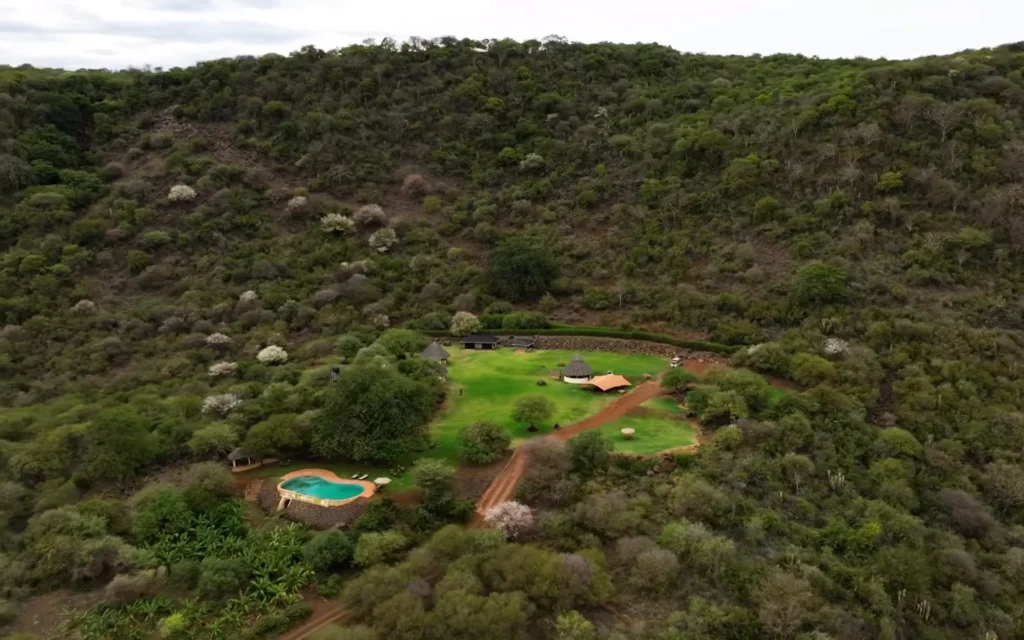
I camped in the Migombani Campsites environs and the background in that aerial shot does not do justice to the background or more to be precise, it does but when we are at ground level it is even more astonishing. The entire estate is located on the forest in a natural bowl. On three sides you are enclosed in canopy and over there in the corner of the bottom is a little pool and at night you can hear the noises in the forest and it is such a way of keeping awake as you can. At about 2am something big was moving across the trees. In the morning the guide said likely buffalo. Probably.
Lake Manyara At a Glance:
| Feature | Detail |
| Park Size | 648 sq km (75% lake surface) |
| Best For | Tree-climbing lions, birdlife, forest walks |
| Entry Fee | ~$53 USD/day non-residents |
| Distance from Arusha | ~126 km, roughly 2 hours |
| Best Season | June–October (dry), Dec–Feb (short dry) |
Ngorongoro Crater: The Place That Shouldn’t Exist

Eight kilometers across. Six hundred meters deep. Roughly 25,000 large animals living inside a collapsed volcano that formed around two million years ago. The Ngorongoro Crater shouldn’t work as an ecosystem — it’s a natural enclosure that somehow sustains itself entirely — but it does and walking out onto the crater rim for the first time and looking down into it is one of those travel moments that resets your sense of scale.
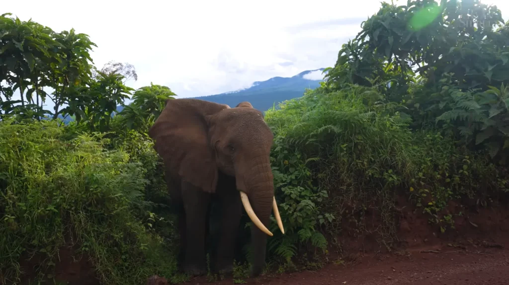
The elephant encounter on the crater road — that was day two inside the park. The track narrows through dense roadside vegetation and then there’s just a bull elephant, enormous, tusks properly long, pushing out of the bushes maybe four meters from the vehicle. The driver went very still. The elephant assessed us, decided we weren’t interesting and went back to eating. My hands were shaking slightly. You don’t fully process how large they are until one is that close.
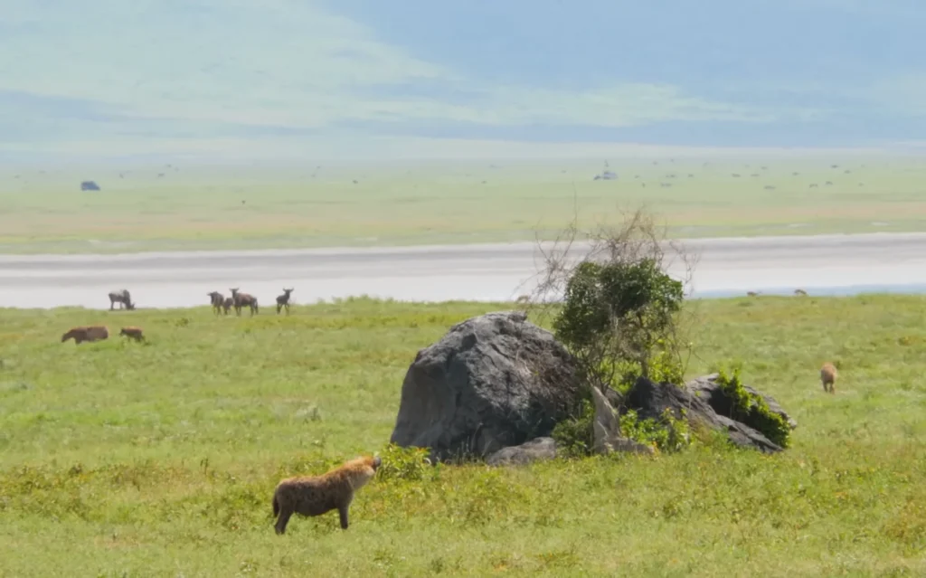
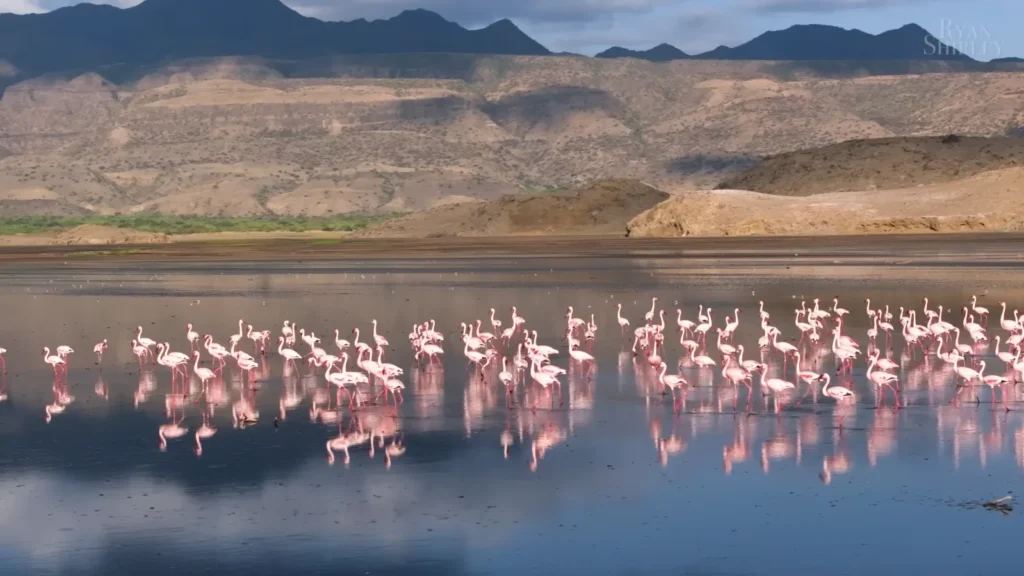
The shot of the wildebeest passing by the flamingos on crater lake, I did see it live and even then I was unable to believe it. There is a shallow soda lake called Lake Magadi that is found in the crater and is fed on by the flamingos and the wildebeest spins around the shore. Two absolutely different races living in one narrow strip of shore and as unmindful of one another as a matter of fact.
Wildlife Commonly Spotted Inside Ngorongoro Crater:
- Black rhino — one of the last stable wild populations in Tanzania, roughly 26 individuals inside the crater.
- Lion prides — the crater’s lions are notably large; isolation has created a distinct genetic subpopulation.
- Spotted hyena — present in surprisingly high numbers, often seen active during daylight hours.
- Cape buffalo — enormous herds graze the crater floor grasslands.
- Flamingo — Lesser and Greater flamingos at Lake Magadi, numbers fluctuate seasonally.
- Elephant — bulls mostly, older males who’ve descended from the rim forests.
The crater does get busy — by 10am the main track near the hippo pool has a queue of Land Cruisers that’s hard to pretend isn’t there. Go in by 6:30am if your lodge allows the early gate opening. The light is better, the crowds aren’t there yet and predators are still active from the night.
Practical Notes for Ngorongoro:
- Park fees are charged per vehicle plus per person — budget carefully, it adds up fast.
- Crater descent is one-way in the morning, one-way out — rangers strictly enforce this.
- You cannot get out of your vehicle on the crater floor except at designated picnic spots.
- The rim lodges have extraordinary views but come at a price — budget camps just outside the conservation area are a solid alternative.
- Ngorongoro Conservation Area Authority manages the whole region, including surrounding Maasai grazing lands.
Lake Natron: The Most Alien Place I’ve Ever Stood
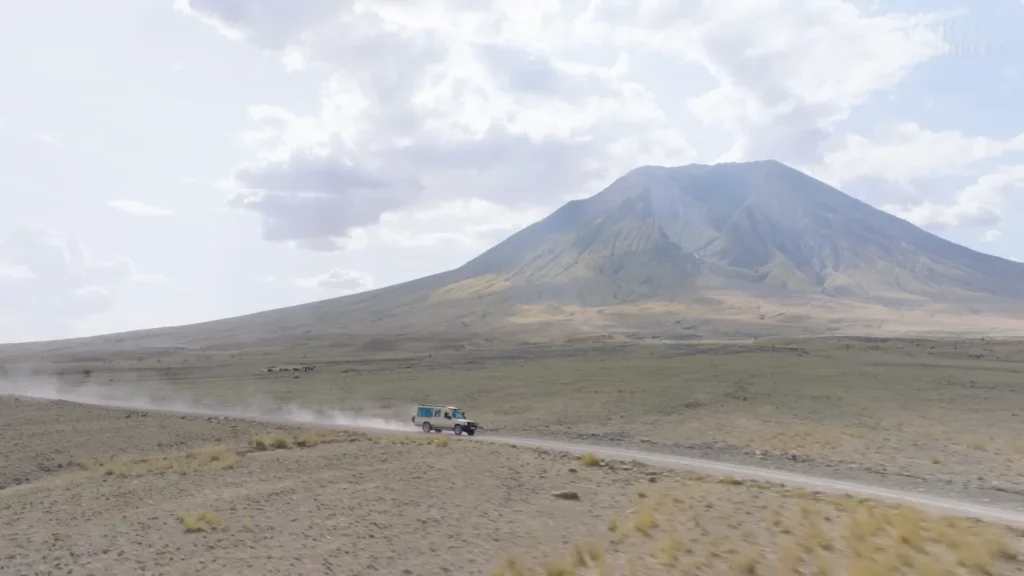
The road to Lake Natron is genuinely bad. Not “a bit bumpy” bad — properly corrugated, dust-everywhere, hold-the-ceiling-handle-for-two-hours bad. That photo of the Land Cruiser kicking up a dust trail with Lengai dead ahead? That’s about hour one. There’s still another hour after that. Nobody warns you adequately.
However, then the landscape begins to act in a strange manner. The vegetation becomes sparse, the soil turns pale grey and there is a slight chemical smell to the air sulphur and something mineral and sharp. This Natron basin is located at the very bottom of the Rift Valley where hot springs and the river Ewaso Ng’iro flow in and the pH of the water is around 10.5. Highly alkaline. Hot wherever the springs are. The type of water that solidifies birds and bats that perish in it and which is both terrifying, as it is and gives rise to some of the most surreal photography you will ever encounter.
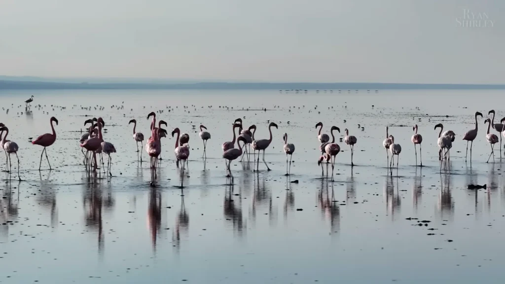
And yet — two million flamingos breed here. Almost the entire global population of Lesser Flamingos nests on Natron’s shores because the caustic water keeps predators away. Nobody else wants to be there. The flamingos have figured this out.
I got to the lake edge around 6am. The water was completely still — no wind yet — and the flamingos were reflected perfectly below them, pink doubled into grey-pink. The silence was the thing I wasn’t expecting. No vehicle noise, no other tourists, just the occasional low honking call moving through the flock like a wave and then settling again.
Later that morning the wind picked up and the whole atmosphere changed — that second shot, with the mountains behind and the light going warm orange-gold, happened maybe forty minutes after the first. Same lake, completely different mood. The rust-colored escarpment walls behind Natron are eroded volcanic rock and against the pink mass of birds they look almost painted.
Lake Natron Fast Facts:
| Feature | Detail |
| Location | Northern Tanzania, Rift Valley |
| Size | Roughly 56 km long, 22 km wide |
| pH Level | 9–10.5 (highly alkaline) |
| Temperature | Up to 60°C near hot springs |
| Flamingo Population | Up to 2 million Lesser Flamingos during breeding season |
| Nearest Town | Engare Sero village |
Getting there requires a registered guide and proper 4WD — I cannot stress this enough. The road is unmarked in places, the lake surface looks solid in spots where it absolutely isn’t and the heat by midday is punishing. My guide Musa had done this route probably two hundred times and still checked the ground before walking near the shoreline.
The Maasai Village: A Moment I Didn’t Photograph
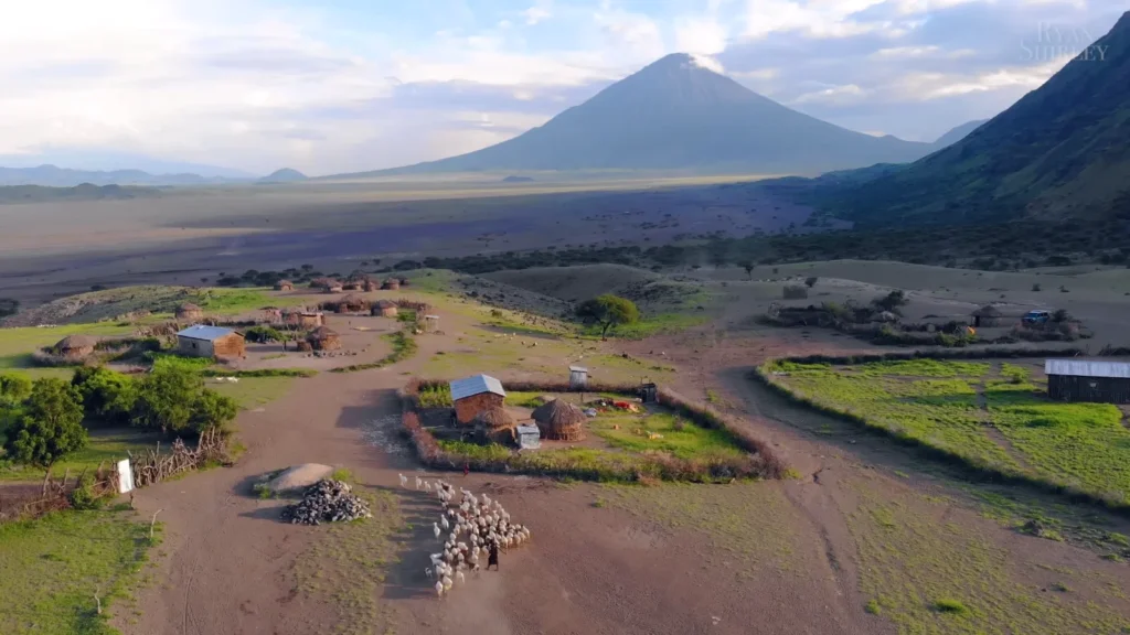
The boma with Lengai in the background of that aerial shot, that light of the golden hour over the entire plain, the herd with moving flock in the compound, I got that when we were shooting at half-past six. However, I did not capture the picture of that evening and that is the version that I recollect better.
We stopped at a small community near Engare Sero. Not a staged cultural visit with a ticket price — just Musa knowing people there, pulling over and us spending about an hour sitting outside while kids who were initially very suspicious of me gradually became very interested in my camera and then wanted to look at every single photo I’d taken that day. An older woman brought out chai that was mostly ginger and incredibly good. Nobody was performing anything. It was just — an evening.
The Maasai of the Lake Natron region and the Lengai region are semi-nomadic and they move cattle depending on grass grazing. The bomas or circular compounds of thorn-bush fence surrounding mud-and-dung huts, can be dismantled and relocated, but many of the communities bordering Natron have become more settled as the tourism and conservation borders have changed their historic tracks.
This section of Tanzania has a complex and ongoing conflict between Maasai land claims and conservation area demarcation boundaries which is not discussed in most tourist guide books. Researchers and activist groups have recorded instances of community coercion out of ancestral land. Something to know before you come and something to spend money on going out with local guides instead of just going through external operators.
If You’re Visiting Communities Around Natron:
- Ask your operator specifically if guides are local and if fees go directly to the community.
- Don’t photograph people without asking — it sounds obvious but gets ignored constantly.
- The Engare Sero community runs guided walks to the lake and Lengai with local Maasai guides — book through them directly where possible.
- Bring something practical to trade or gift if invited — sugar, tea, basic medicines — rather than sweets or money handed to children.
Ol Doinyo Lengai: The Most Brutal Hike I’ve Ever Done and I’d Do It Again Tomorrow
Ol Doinyo Lengai translates to Mountain of God in Maa, Maasai language and the Maasai view it as sacred, which is very natural after viewing the mountain and it’s breath near the top.
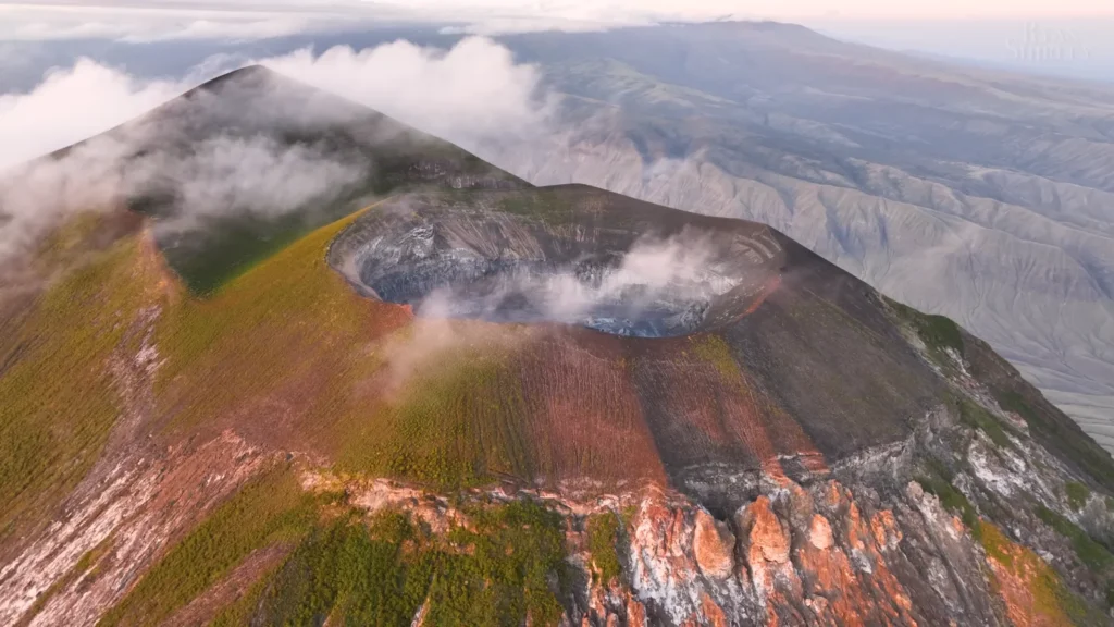
It is the sole volcano on the planet that spews out natrocarbonatite lava -carbonatite as opposed to silicate. which means that the lava will not melt down to 1,200 o C, as it ordinarily does, but perhaps to no more than 500 o C, is nearly black and solidifies in a few hours in it’s new form of white crusts of calcite that bear no resemblance to any other volcanic rock you have ever seen. The inner parts of the crater resemble a fever dream gray and white intrusions, gasses going out of it, landscape about which we have the impression that it is not on this planet.
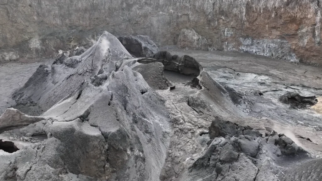
That crater shot — the grey sculptural formations with white crusts and faint steam coming off them — that’s what the inside actually looks like. I was there for maybe twenty minutes before the guide said we needed to move. The ground temperature near active vents is not something you want to test.
The hike itself starts at midnight. Not because that’s fun, but because the equatorial sun on a near-vertical black volcanic slope at noon would kill you — not exaggerating. The gradient averages around 45 degrees on the upper section. You’re essentially climbing on loose volcanic scree for three to four hours in the dark, headlamp aimed at your next handhold, the valley floor lights getting smaller below you. I stopped tracking time around hour two because it wasn’t helping.
Summit at around 4am. Cold, windy and then slowly the Rift Valley floor reveals itself as the sky lightens — Lake Natron below going pink, the escarpment walls turning amber, Kilimanjaro’s snow cap catching first light somewhere to the south-east.
Ol Doinyo Lengai Climb — What You Actually Need to Know:
- Start time: Midnight. Non-negotiable if you want summit before heat.
- Duration: 4–6 hours up depending on fitness, 2–3 hours down.
- Difficulty: Extremely hard — loose scree, near-vertical sections, zero shade.
- Guide: Mandatory — Engare Sero village guides know the route and conditions.
- Fitness requirement: High — Kilimanjaro veterans have turned back on this mountain.
- Active volcano status: Check GVP Smithsonian for current activity before booking.
- What to bring: Headlamp with spare batteries, trekking poles, warm layers for summit, 3+ liters water minimum.
The descent wrecked my knees for three days. Worth every moment.
Zanzibar: Switching Off After Two Weeks of Not Switching Off
The flight from Arusha to Zanzibar takes about 45 minutes. The psychological distance is considerably further.
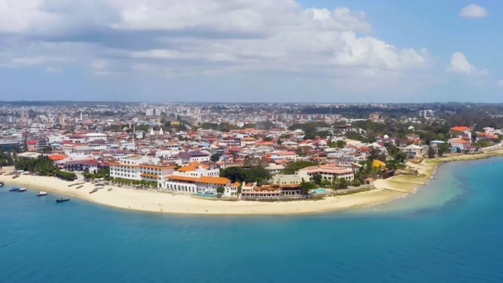
Stone Town hits you visually the second you see it from above — that curve of colonial architecture right on the waterfront, white and terracotta, minarets punctuating the roofline, the Indian Ocean sitting an impossible shade of blue against the sand. It’s a UNESCO World Heritage Site and you understand why almost immediately — the Stone Town streetscape is genuinely unlike anywhere else, a physical record of Arab, Omani, Portuguese, Indian and British trade influences layered across five centuries.
I spent two nights in Stone Town before heading to the north coast. The narrow streets — and they are narrow, the kind where two people with bags have to turn sideways — are full of carved wooden doors, each one slightly different, the craftsmanship apparently a historical indicator of the owner’s wealth and status. I got lost twice, found a rooftop restaurant by accident both times and had the best octopus I’ve eaten anywhere on the second evening at the Forodhani Night Market. Grilled fresh, served with lime, cost almost nothing.

Nakupenda or I love you, is a sand bar a 10 minutes boat ride off of Stone Town and it literally appears and disappears with the tide. During the low tide it is a due strip of white sand with water all around it shifting between turquoise and deep blue in the depth. On Wednesday, I was there, expecting it to be not as busy as weekends. It wasn’t. But really what colour that water is makes all things make-up.
Zanzibar Snapshot:
| Best beaches | Nungwi, Kendwa, Paje (kite surfing), Matemwe |
| Stone Town essentials | Forodhani Market, House of Wonders, Old Fort, carved door trail |
| Day trips | Nakupenda sandbar, Prison Island (giant tortoises), Jozani Forest (red colobus monkeys) |
| Spice tours | Half-day tours from Stone Town — cloves, vanilla, nutmeg, all still actively farmed |
| Getting there | Domestic flights from Arusha (~45 min) or ferry from Dar es Salaam (~2 hrs) |
The Jozani Chwaka Bay National Park, in the interior of Zanzibar, is well deserved half a day – the endemic Zanzibar red colobus monkey can be found nowhere on the planet and the walk through the forest brings you within a few meters of them. Lazy, used to having people around, not in the least bothered by your arrival.
What Nobody Mentions About Zanzibar:
- The tides genuinely matter — many beaches are not swimmable at low tide, which can shift dramatically within hours.
- Dress conservatively in Stone Town — it’s a predominantly Muslim community and the local culture deserves that basic respect.
- Negotiate dhow and boat trips directly with fishermen at the waterfront rather than through hotel desks — significantly cheaper and the money goes directly to the right people.
- The Swahili Coast sea trade history is genuinely fascinating and a bit of reading before you go makes Stone Town make considerably more sense.
What Tanzania Actually Costs: The Honest Numbers
Nobody writes this part clearly enough. Every travel article I read before this trip either glossed over costs entirely or quoted figures so vague they were useless. So here’s what I actually spent, roughly, as a solo traveler doing the northern circuit plus Zanzibar over eighteen days.
Tanzania is not a cheap destination. I want to be upfront about that. The park fees alone are structured specifically for international visitors and they add up faster than you’d expect — not because they’re unreasonable given what you’re seeing, but because nobody mentally prepares for the cumulative total.
Rough Cost Breakdown Per Person:
| Expense Category | Approximate Cost (USD) |
| Kilimanjaro climb (Machame, 7 days, all inclusive) | $2,000 – $3,500 |
| Northern circuit safari (5 days, budget operator) | $1,500 – $2,500 |
| Northern circuit safari (5 days, mid-range) | $3,000 – $5,000 |
| Mount Meru climb (3 days) | $700 – $1,200 |
| Lake Natron + Lengai excursion (2 days) | $300 – $600 |
| Zanzibar accommodation (per night, mid-range) | $60 – $180 |
| Arusha accommodation (per night, guesthouse) | $25 – $80 |
| Domestic flight Arusha–Zanzibar | $120 – $200 |
| Visa on arrival | $50 |
| Travel insurance (18 days, adventure cover) | $150 – $300 |
The single biggest mistake budget-conscious travelers make is booking the cheapest safari operator without checking what’s included. I spoke to a couple at Ngorongoro who’d paid rock-bottom prices and discovered their “park fees included” contract had a different interpretation than theirs did. Get everything itemized in writing. The Tanzania Association of Tour Operators maintains a list of registered operators — start there.
Where You Can Actually Save Money:
- Accommodation in Arusha — the city has solid guesthouses in the $25–40 range that are genuinely fine.
- Stone Town, Zanzibar — smaller locally-owned guesthouses beat the resort prices significantly and you’re more central.
- Forodhani Market dinners instead of hotel restaurants every night — the food is better anyway.
- Booking Meru and Natron excursions through Arusha-based local operators rather than international booking platforms.
Where You Absolutely Should Not Cut Corners:
- Kilimanjaro operators — the difference between a $1,800 and $2,800 climb is usually guide quality, porter wages and emergency oxygen on the mountain.
- Travel insurance — specifically one that covers high-altitude evacuation, which standard policies often exclude. World Nomads is what I used; the adventure sport extension covered Kili and Lengai.
- Guides for Lengai — this is an active volcano with unpredictable venting. The $80 guide fee is not optional.
When to Go: The Answer Is More Complicated Than “Dry Season”
Best Times to Visit Tanzania — By Activity:
| Activity | Best Months | Notes |
| Kilimanjaro climb | Jan–Mar, Jun–Oct | Avoid long rains April–May |
| Northern circuit safari | Jun–Oct | Dry season, animals concentrate near water |
| Calving season (Ngorongoro/Serengeti) | Jan–Feb | Predator activity peaks |
| Lake Natron flamingos | Sep–Oct | Peak breeding numbers |
| Ol Doinyo Lengai climb | Jun–Oct | Drier, more stable conditions |
| Zanzibar beaches | Jun–Oct, Dec–Feb | Avoid long rains May–Jun |
| Zanzibar kite surfing | Jul–Sep | Southeast trade winds |
The honest version: January and February are underrated. Yes, it’s technically the short dry season rather than the main dry season, but Ngorongoro in January with the calving season underway is extraordinary — predator activity is intense, the grass is still green enough to look good in photographs and there are fewer vehicles than July or August. That’s when I went and I’d go again in the same window.
The long rains — roughly March through May — are when most people don’t go and for climbing that’s reasonable. But for the parks themselves, the light can be spectacular, prices drop and you’ll have lodges largely to yourself. Just account for some roads becoming genuinely impassable.
Getting Around: What Nobody Explains Properly
Arusha is your base. Everything on the northern circuit radiates out from there and comes back through there. The city has enough infrastructure to make logistics manageable — if slightly chaotic.
Transport Options, Ranked by Practicality:
- Safari vehicle with operator — the default for park visits. You cannot self-drive in most national parks in Tanzania.
- Private car hire — works for Arusha city and the surrounding area, negotiate daily rates with local drivers.
- Dalla-dallas — local minibuses, cheap, crowded, fine for getting around Arusha town if you’re not in a hurry.
- Domestic flights — Coastal Aviation and Auric Air cover Arusha to Zanzibar, Serengeti airstrips, Ruaha and more. Worth it for long distances.
- Ferry Dar es Salaam to Zanzibar — Azam Marine runs the crossing in about 2 hours. Cheaper than flying, more interesting.
A word on the Arusha–Natron road specifically. It’s doable in a standard 4WD but gets dramatically worse after any rain. My driver — a genuinely unflappable man named Patrick who’d been driving that route for eleven years — told me the record he’d witnessed for a vehicle getting stuck was six hours. We did not break that record, which I consider a personal success.
Health, Safety and the Practical Realities
Before You Go:
- Yellow fever vaccination required if arriving from certain countries — check current requirements with your embassy.
- Malaria prophylaxis strongly recommended for most of Tanzania — discuss with a travel health clinic, not just a general practitioner.
- Hepatitis A and typhoid vaccinations advised.
- Altitude sickness is real above 3,000 meters — Diamox (acetazolamide) is worth discussing with your doctor before Kilimanjaro.
- Comprehensive travel insurance with evacuation cover — non-negotiable.
On the Ground:
Tanzania is genuinely one of the safer countries in Africa for tourists and I never once felt unsafe in eighteen days. That said — a few practical realities that apply:
- Keep a small amount of cash in Tanzanian Shillings for markets and smaller purchases; USD is widely accepted but you’ll get worse rates.
- ATMs in Arusha are reliable; in smaller areas like Natron, there are none — plan accordingly.
- The Tanzania Tourist Board maintains a helpline and can verify registered operators if you have doubts.
- Photography near military installations, government buildings and certain border areas is restricted — when in doubt, ask before pointing a camera.
Tanzania in a Table: Full Trip Overview
| Destination | Days Recommended | Highlight | Don’t Miss |
| Arusha | 1–2 | City base, Mount Meru views | Maasai market, local chapati |
| Mount Meru | 3–4 | Summit above clouds | Colobus monkeys on lower slopes |
| Kilimanjaro | 6–8 | Uhuru Peak glacier views | The Barranco Wall scramble |
| Arusha National Park / Napuru | 0.5–1 | Montane forest trail | The waterfall grotto |
| Lake Manyara | 1–2 | Tree-climbing lions | Dawn game drive before crowds |
| Ngorongoro Crater | 1–2 | 25,000 animals in one bowl | Early morning predator activity |
| Lake Natron | 2 | Flamingo breeding colony | Sunrise at the lake edge |
| Ol Doinyo Lengai | 1 (overnight hike) | Active volcano crater | Rift Valley at first light |
| Maasai Villages | Half day | Authentic community life | Engare Sero local guide |
| Zanzibar | 3–5 | Stone Town, Nakupenda sandbar | Forodhani night market |
Closing Thoughts: The Thing About Tanzania

That photo of the camp near Natron — those tan canvas tents scattered across a dry rocky valley, mountains behind, nothing else for kilometers — was taken on night three of what ended up being my favorite stretch of the whole trip. No Wi-Fi. Spotty cell signal. Dinner cooked over a gas flame that tasted unreasonably good because everything does when you’ve been outside all day.
Tanzania is the kind of place that makes a lot of other travel feel slightly ordinary afterward. Not because it’s perfect — the roads are rough, the logistics are expensive, the altitude will humble you and the volcano hike will destroy your knees — but because nowhere else have I experienced such genuinely varied landscape and wildlife packed into one country. A week into the trip I’d already been through rainforest, alpine desert, volcanic crater and soda lake. I still had the Rift Valley, a Maasai village at sunset and Zanzibar’s Indian Ocean ahead of me.
The thing I’d go back for first, unexpectedly, is the Napuru jungle trail. That stream, those orange flowers, the colobus monkey crashing through branches above my head. Not the summit view, not the flamingos — though both were extraordinary. Just a quiet forest path that nobody pointed me toward and that I almost didn’t take.
Go. Take the rough road. Stay an extra night when something surprises you. The mountain will still be there in the morning.