
The Indiana Travel Advisory Map is the state’s official, county-by-county way of telling you whether the roads are open, dicey or closed to everyone but emergency crews. It runs on a color system: yellow for caution, orange for essential trips only, red for stay put or risk a ticket. The live version sits on the Indiana Department of Homeland Security site and refreshes every few minutes during a storm. Drive into a red county and you can be fined up to $500, so a thirty-second check before you pull out of the driveway pays for itself.
Key Takeaways
- The map is run by the Indiana Department of Homeland Security and set locally, so two neighboring counties can carry different statuses in the same storm.
- Yellow means use caution, orange means essential travel only and red closes the roads to all but emergency personnel.
- The official map lives at in.gov/dhs/travel and updates roughly every five minutes when weather is active.
- Ignoring a red Warning is a Class C infraction carrying a fine of up to $500 and your vehicle can be towed at your own expense if it blocks plows or responders.
- Google Maps and Waze don’t pull in these advisory levels, so you have to check the state map yourself.
Why Every Indiana Traveler Needs This Map
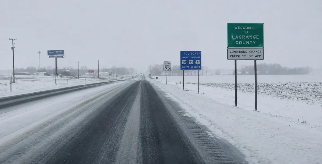
I learned to respect this map on a December drive that should have been simple. It was right around the holidays a few winters back and I was trying to get across the middle of the state when an overnight storm turned the northern half into a mess. Counties I’d planned to roll straight through, Grant and Wabash among them, had flipped to a red travel advisory by morning. I only found out because a gas station clerk mentioned it. Forty-odd miles of my route were, on paper, off-limits to anybody who wasn’t a first responder.
What makes Indiana different from a lot of states is that the advisory isn’t a polite nudge from a weather app. It’s a local government call with real teeth, made by county commissioners or emergency management directors watching their own roads in real time. And because the decision happens at the county line, your trip can cross three or four jurisdictions that each see the storm differently. Check only where you’re starting and you’ve checked almost nothing. The whole point of the map is the route, not the dot you’re standing on.
Decoding the Colors: Advisory, Watch, Warning
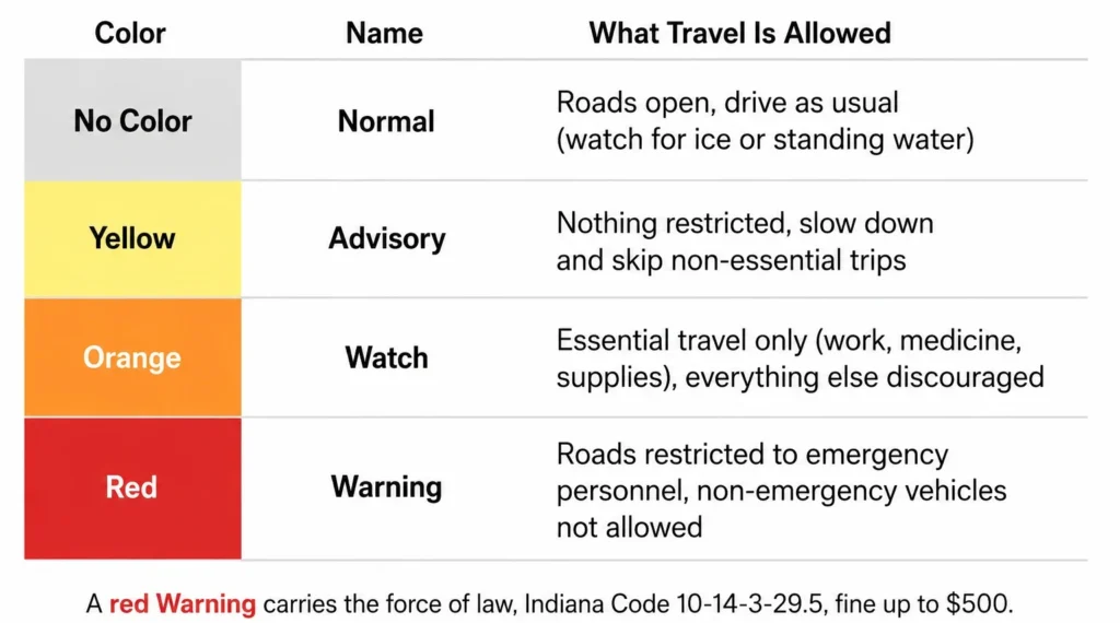
There are four states on the map and the simplest way to hold them in your head is a ladder running from “go ahead” up to “absolutely not.”
No color means normal. Roads are open and you drive like any other day, though normal status doesn’t promise the pavement is free of ice patches or standing water. Yellow is an Advisory, the lowest active alert. Nothing is restricted; you’re just being told to slow down and skip the non-essential trips if you can. Orange is a Watch and the bar rises here. Only essential travel is meant to happen, the kind of thing like getting to work, picking up medicine or grabbing supplies and everything else is strongly discouraged. Red is a Warning, the top of the ladder. Roads are restricted to emergency personnel, a county state of emergency is usually in force and non-emergency vehicles are simply not allowed out.
The legal weight behind all of this comes from Indiana Code 10-14-3-29.5, which gives a red Warning the force of law. Breaking it is a Class C infraction with a fine of up to $500 per violation and if your stranded car is in the way of a plow or an ambulance, it gets towed and you pay for the tow. You can always confirm your county’s current color on the state’s official county travel status map.
Where to Find the Official Map & How to Check Your Route
The DHS map is your source of truth, but it isn’t the only screen worth opening. INDOT folds the same county advisories into its 511 traveler information system, layering them over live road closures, construction and traffic-camera feeds, so you see advisory level and actual road conditions in one place. The Indiana 511 mobile app does the same on your phone and if you’d rather listen than look, 800-261-7623 reads you a spoken travel report. Whatever you pick, check the full route county by county, not just the town you’re pulling out of.
What Happens If You Ignore a Red Warning?
Roll into a red county anyway and the consequences stop being theoretical. Local police can enforce the ban and a violation runs up to $500 as a Class C infraction. If your car slides off and blocks a plow route or an ambulance, it gets towed at your own expense and you’ve now made the road more dangerous for the crews trying to clear it. Even an orange Watch carries a quieter risk worth knowing: drive for a non-essential reason, get into a wreck and your insurer may push back on the claim.
My Personal Rule as a Traveler During Indiana Winters
My rule from November through April is dull and it has never let me down. I check the map before I start the engine, then again at every fuel stop. I keep the state map and my navigation app open side by side, because Waze and Google Maps won’t warn me about an advisory level. They’ll happily route me straight into a red county. And if you’re driving anything tall, an RV, a box truck, a high-roof van, treat a yellow the way most drivers treat an orange. The same crosswinds that close roads punish high-profile vehicles first and plenty of trucking fleets ground their rigs at advisory levels the rest of us drive through.
None of this takes long. One look at the map before you leave, one more at each stop and you’ve spared yourself a fine, a tow or a much worse afternoon stuck on a closed road. In an Indiana winter, that quick check is just part of getting in the car.