
And, here is the brief version, prior to plunging into it, the map of Europe in 1914 was already torn in before a single shot was discharged. Failing states clinging together with diplomatic tape, an alliances system so inflexible that a single killing in a medium-sized city in Bosnia pulled in all the great powers on the continent and – this one comes as a big surprise – there was no Poland. Not on any map. Hadn’t it been a century. The boundaries were not mere lines. They were grievances, and the grievances at length came together in 1914.
The Great Powers: Who Actually Ran Europe
Seven states. That’s roughly who mattered in 1914 Europe if you were thinking about war, trade, or survival. But “state” is doing a lot of work here — some of these were genuinely modern nations, others were ancient empires held together mostly by inertia and fear.
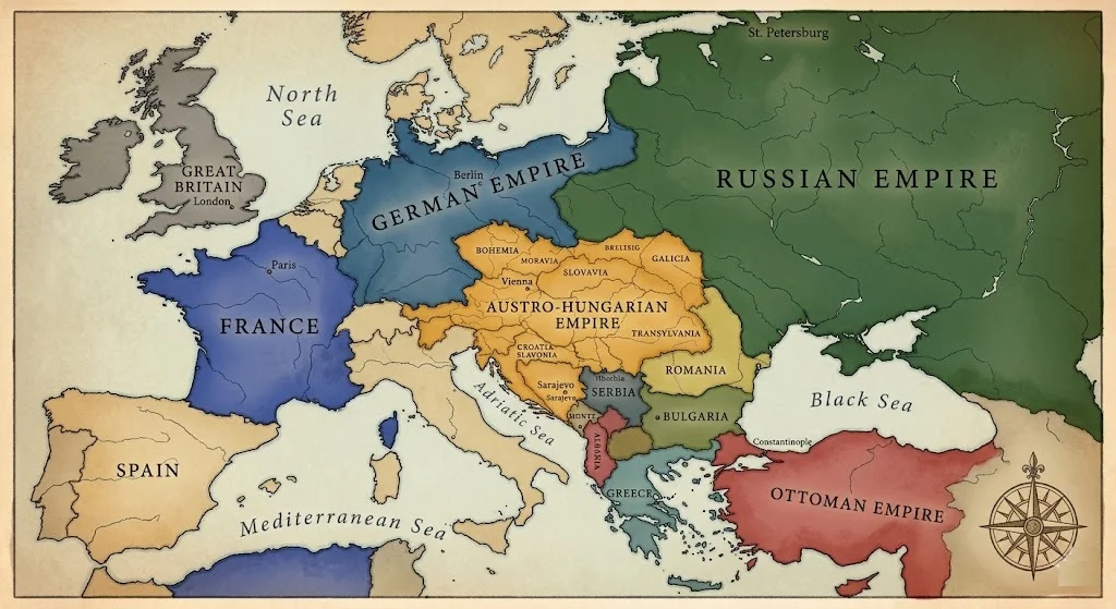
- The British Empire was the world’s largest, though most of it wasn’t in Europe. On the continent Britain was a naval power with a studied reluctance to get involved in land wars — until Germany’s expansion made that reluctance impossible to maintain.
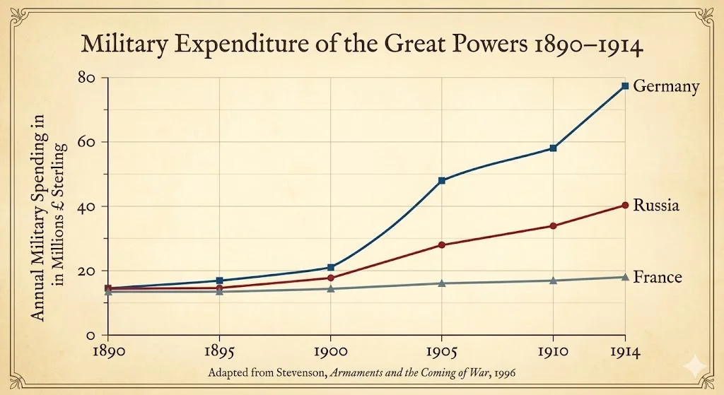
- The German Empire is where the anxiety lived. Unified only in 1871, it industrialized faster than anyone expected. By 1914 its military spending dwarfed France’s. Kaiser Wilhelm II wanted a place in the sun — his phrase, not a metaphor — and the older powers found that unsettling in a way that shaped every alliance decision after 1890.
- France In 1871 was still green. Gave Alsace-Lorraine to Germany in the Franco-Prussian War and never relinquished it. That injury–revanchism, as the historians term it–was silently guiding French foreign policy in forty years.
- The one which deserves more attention than it is accustomed to receive is Austria-Hungary. Formally known as the Austro-Hungarian Dual Monarchy, it was in reality 17 crown lands, roughly 11 major ethnic groups and a bureaucracy struggling to keep the lot together with an emperor, Franz Joseph, who had been on the throne since 1848. That’s not a typo. Since 1848. The man was ruling since even before the American Civil War. The empire was worn out.
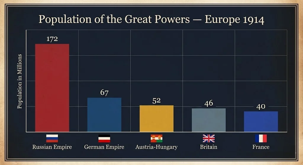
- Russia was massive and scary on paper. 172 million people. But its military modernization was incomplete, its internal politics were a mess, and the 1905 revolution against Tsar Nicholas II had rattled the whole structure. Still — nobody wanted to fight it. The sheer size made everyone nervous.
- Decades had been passing the Ottoman Empire on its deathbed. The phrase was “Sick man of Europe,” and it was not very nice but it was not very untrue, either. By 1914 it had almost forfeited what it used to possess in the Balkans. In Europe was left a narrow belt running around Constantinople.
- Italy was now united in 1861 and desired to be considered as a great power. Spoiler: it was in the Triple Alliance with Germany and Austria-Hungary but crossed over in 1915. Take of that what thou wilt.
The Alliance System: How a Local Murder Became a World War
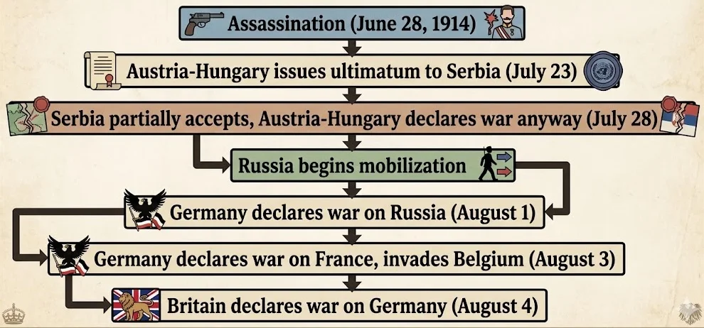
This is the part that law students actually find interesting and they should. These alliances were treaties. Binding, signed, ratified obligations. When Austria-Hungary declared war on Serbia, the treaty architecture activated almost automatically. It’s one of history’s more brutal examples of contractual obligation producing catastrophic outcomes nobody individually wanted.
Two blocs. That’s what Europe had built by 1907.
| Alliance | Members | Core Motivation |
| Triple Alliance | Germany, Austria-Hungary, Italy* | Mutual defense; Germany-Austria fear Russia and France encirclement |
| Triple Entente | France, Russia, Britain | Counter German expansion; France-Russia fear Germany; Britain fears naval threat |
Italy declared neutrality in 1914 as a member and in 1915, it joined the Entente.
The Triple Alliance was formed in the first place -1882. It was orchestrated by Germany, Bismarck, who thought that he did this partly to isolate France, and partly to ensure that Austria-Hungary and Russia did not have each other by the throats in the Balkans. It was, when Bismarck was about. The balancing act became relatively unstable after Wilhelm II ousted him in 1890.
In 1894, France and Russia signed their alliance. Britain was longer—it has always been averse to continental involvements–but with the naval armament of Germany the reckoning was altered. In 1907 the Triple Entente was a fact, less of a proper military alliance than a series of agreements. Enough to be mobilized by the time it was needed.
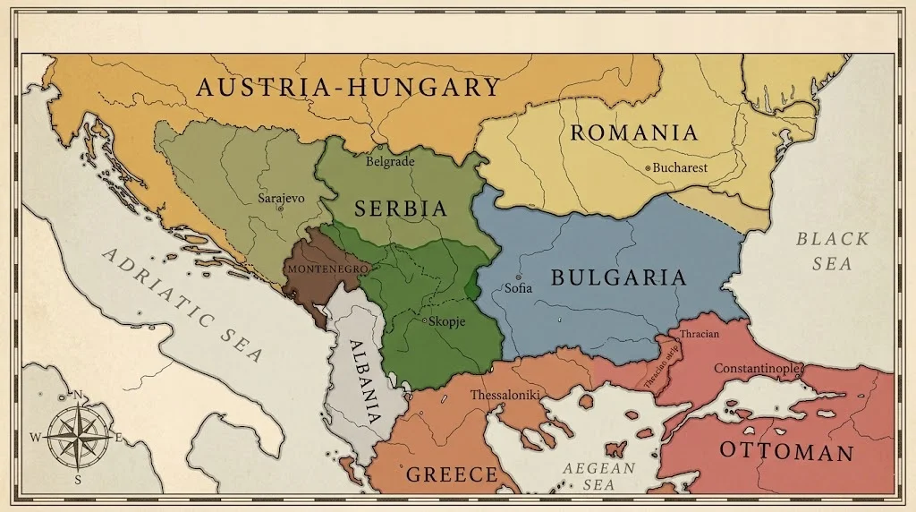
The Balkans: The Actual Powder Keg
Powder keg is a phrase that is tossed around by people without them taking the time to ponder on what that phrase entailed. The Balkans in 1914 were not only tense. It had been two years since they had already fought two wars. The earth was yet new, complaints were yet warm and three empires of conflicting interests were all crowding into the same little geography at the same time.
This is what had really occurred in these two wars, as they are vital to the perception why Sarajevo was the starting point rather than another political assassination.
- The 1912 First Balkan War. The Balkan League, consisting of Serbia, Bulgaria, Greece and Montenegro, is an impressive feat of coordinating four nations that did not exactly trust one another, and pushed the Ottoman Empire out of virtually all of the remaining European territory. Shockingly fast. Four weeks more of hard struggle and the Ottomans were virtually out of Europe. It was formalized in the Treaty of London in 1913.
That treaty created binding territorial obligations. New borders, recognized internationally. And immediately caused the next war.
- The Second Balkan War, 1913. The alliance dissolved the moment they had to divide the spoils. Bulgaria felt cheated on its share of Macedonia. Serbia and Greece disagreed. Romania jumped in. The Ottoman Empire — just defeated — also attacked Bulgaria to recover some territory. Bulgaria lost badly. Serbia came out of it having nearly doubled in size and feeling, for the first time in a long while, genuinely powerful.
That last part terrified Austria-Hungary.
A confident, expanding Serbia on its southern border, with a large Serb population already living inside Austro-Hungarian territory — this was the nightmare scenario for Vienna. Serbian nationalism wasn’t abstract. It had momentum, recent military victories, and a name: the Black Hand, the secret society Gavrilo Princip was loosely connected to when he shot Franz Ferdinand in June 1914.
The Absence of Poland: The Map’s Most Telling Blank Space
First time most people look at a 1914 map of Europe, they notice something feels off before they can name it. Then they realize — Poland isn’t there.
Not since the late 18 th century. Between 1772 and 1795, the Polish-Lithuanian Commonwealth was dismembersed in three parts, divided between Russia, Prussia and Austria until there was no more. A whole nation, complete with its language, culture, centuries of separate history, was just another settlement on the estate, cut up between neighbors.
By 1914 Polish territory was split three ways:
- Russian partition — the largest share, called Congress Poland, under Tsar Nicholas II. Polish language suppressed in schools, Russian imposed.
- German partition — Prussian Poland, where Bismarck had run aggressive Germanization campaigns in the 1870s and 80s.
- Austrian partition — Galicia, actually the most livable situation for Poles. Austria-Hungary’s internal complexity meant it couldn’t afford aggressive cultural suppression — too many other groups to manage simultaneously.
This matters for the war in a way that doesn’t get enough attention. When fighting broke out, Poles found themselves conscripted into three different armies — Russian, German, Austro-Hungarian — sometimes literally fighting against each other depending on which side of a partition line their village fell on. The absurdity of that situation is hard to overstate.
Poland re-emerged on the map in 1918, after the war, when all three empires that had partitioned it collapsed simultaneously. That’s one of history’s stranger coincidences — or not a coincidence at all, given that the war destroyed exactly the powers that had been suppressing Polish independence for 120 years.
Alsace-Lorraine: The Border That Wouldn’t Heal
Should Poland be the blank spot on the map of 1914, Alsace-Lorraine is the unhealed wound on the west side.
The Franco-Prussian War of 1871 led to the loss to Germany of those two provinces of France. No little defeat, Alsace-Lorraine had deposits of iron ore, industrial facilities and about 1.5 million inhabitants who spoke a Germanic dialect but had been French nationals. Bismarck desired the land because it provided strategic depth, as well as because of the resources.
French public opinion never accepted it. Revanchism — the political desire to take it back — became almost a cultural identity. Statues in Paris representing the “lost provinces” were draped in black fabric for decades. Kids learned about it in school as a national humiliation requiring correction.
Germany, meanwhile, governed Alsace-Lorraine as an imperial territory rather than integrating it fully — which managed to alienate the population without satisfying French demands. By 1914 it had been German territory for 43 years and was still functionally contested ground.
When war came, recovering Alsace-Lorraine was France’s primary war aim. Not democracy, not stopping German expansion in the abstract — getting those provinces back. That specificity shaped French military strategy, French willingness to sustain catastrophic casualties, French insistence at Versailles in 1919 that the territory be returned. Which it was.
Sarajevo: What Actually Happened and Why the Map Made It Inevitable
June 28, 1914. A Sunday. Franz Ferdinand and his wife Sophie are riding in an open carriage through Sarajevo, the capital of Bosnia, annexed by Austria-Hungary only six years earlier, in 1908, amid Serbian and Russian protests which never completely abated.
In fact, there were several attempts of assassination during the morning. People forget that. A bomb was hurled at the car of the Archduke earlier in the procession,–it bounced off, and hit the next vehicle, injuring several. Franz Ferdinand proceeded to the town hall, delivered his appointment speech, after which he decided to go to the hospital to see the victims of the previous attack.
His driver took a wrong turn.
Gavrilo Princip, 19 years old, was standing outside a delicatessen on Franz Josef Street — having essentially given up on the day after the failed bomb attempt — when the Archduke’s car pulled up directly in front of him while the driver was trying to reverse. He fired twice. Franz Ferdinand and Sophie were both dead within the hour.
The fact that the wrong turn is described is important, as it deprives any historical inevitability of the act at hand. It was provisional, anarchic, near accidental in its ultimate performance. It was not incidental that the map had created beneath itself all that the map had created above it–the alliances, the grievances, the Austro-Hungarian paranoia of Serbian growth, the Russian promise of Slavic security, the Russian obligation to uphold treaties with Russia, that which France had pledged to protect Serbia.
The map made the murder matter beyond Sarajevo.
The Congress of Vienna’s Long Shadow
One thing worth understanding — the 1914 map wasn’t random. It had a specific architect: the Congress of Vienna, 1815.
After Napoleon, the major powers sat down and redrew everything. Britain, Austria, Prussia, Russia — the victors — created what they called the Concert of Europe. The idea was collective management of the continent’s affairs, a balance of power preventing any single state from dominating. It worked, more or less, for about a century. No continent-wide war between 1815 and 1914.
But the Congress of Vienna drew borders based on dynastic legitimacy and great power interests, not ethnic or national ones. It had no framework for nationalism — the idea that Poles, Serbs, Czechs, or Romanians might want their own states wasn’t really on the table in 1815. By 1914 that oversight had accumulated a hundred years of pressure.
All the border conflicts on the map of 1914 are partially connected to the settlements of Vienna. Alsace-Lorraine Vienna redid the border arrangements in 1871 with the German victory. The Balkans Ottoman decline left a vacuum that was never envisioned by Congress. Poland – the division that Vienna signed and solidified.
The Concert of Europe gave the continent stability. It also locked in arrangements that nationalism would eventually explode.
Why Any of This Still Matters
Treaties created this war. That’s the legal researcher’s takeaway if there is one.
The alliance obligations weren’t suggestions. When Austria-Hungary moved against Serbia, the treaty architecture activated in sequence — Russian mobilization triggered German declarations, German invasion of Belgium triggered British entry. Individual statesmen had some room to maneuver in July 1914, historians still argue about how much, but the structural pull of signed commitments was enormous.
The Treaty of London from 1839 — guaranteeing Belgian neutrality — is what formally brought Britain in. Germany’s chancellor Bethmann Hollweg reportedly called it “a scrap of paper.” Britain went to war partly over that scrap of paper. 700,000 British dead before it was over.
Treaty obligations, border grievances, alliance architecture built over decades — the 1914 map wasn’t a snapshot of a stable continent. It was a document of accumulated commitments and resentments that needed only a trigger. Princip provided the trigger. The map provided everything else.
Final Word
The WW1 map of Europe before the war is worth studying not because it’s history but because it’s a masterclass in how structures — legal, political, geographic — create outcomes that individuals inside them can barely influence. Franz Ferdinand’s driver took a wrong turn. Princip happened to be standing there. But the war that followed wasn’t about either of those things.
It was about the map.