
I’ve spent a fair amount of time in Guatemala’s Western Highlands over the years and the question I get most from fellow travellers is some version of “but is it actually safe?” For San Marcos and Huehuetenango specifically, the honest answer is: it depends entirely on what you do there, how you move around and whether you’ve done your homework. I’ve gathered the facts, cross-referenced the government advisories and spoken to people on the ground. Here’s what you actually need to know.
Key Takeaways
- Both departments are lower in violent crime than Guatemala City or the Pacific lowlands, but petty theft, road robbery and trafficking-linked violence exist in specific zones.
- The UK FCDO and US State Department advise against travel within 5km of the Mexican border in both departments – this is a hard line worth respecting.
- Volcano hikes (Tajumulco, Tacaná) carry a non-zero robbery risk; never go without a vetted local guide.
- Roads after dark are genuinely dangerous – not advisories-speak, actually dangerous
- Altitude sickness is a real medical risk on highland routes; acclimatise before any serious trekking.
- Overall verdict: manageable with preparation, specific zones to avoid, not a place to wing it.
The Reality of Crime in the Highlands
San Marcos and Huehuetenango sit well outside Guatemala’s most violent zones. You won’t find the gang-controlled urban blocks you’d encounter in parts of Guatemala City or Escuintla here. What you will find is opportunistic theft – bag snatching in crowded markets, pickpocketing on chicken buses, the occasional armed robbery on a remote secondary road after dark. The US State Department currently rates Guatemala at Level 3 overall, with specific language warning against remote areas near the Mexican border in both departments.
The thing that catches most hikers off guard is Tajumulco. Central America’s highest peak sits at 4,220 metres and is an obvious draw – but the trailhead is remote, police presence is minimal and there’s a documented history of armed robberies targeting hiking groups. The situation has improved since 2024 with community policing initiatives, but the risk hasn’t gone to zero. A thread on r/solotravel from a 2024 Tajumulco hiker puts it plainly: the guide wasn’t optional, it was the difference. Hire through a registered network like Quetzaltrekkers or a community tourism committee. Don’t carry anything on the trail you’d mind losing.
Transnational gangs – MS-13, Barrio 18 – are present in Guatemala but their footprint in the Western Highlands is smaller than in urban centres. What does affect locals here is extortion: the “war tax” that squeezes businesses and transport on the outskirts of both departmental capitals. Travellers aren’t the target, but staying aware of the environment matters.
Navigating Roads and Transport Safely
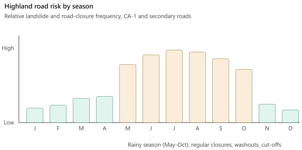
The Pan-American Highway (CA-1) running through both departments is paved and heavily used during daylight – relatively safe by regional standards. Once you leave it, the calculus changes fast. Secondary roads to places like Todos Santos or the Tajumulco trailhead are unpaved, heavily rutted and can turn impassable after rain without 4WD. The rainy season runs May through October and landslides regularly cut routes for hours or days, particularly between San Cristóbal and the Cuatro Caminos junction.
Public chicken buses are the local backbone and they’re dirt cheap, but they’re also overloaded, under-maintained and have no seatbelts on roads that would challenge a professional rally driver. Robberies on early-morning and late-night runs have been reported. My strong preference is tourist shuttles from Xela or a private driver arranged through your accommodation. It costs more. It’s worth it. For intercity runs, first-class operators like Línea Dorada are a reasonable middle ground.
One thing that doesn’t make it into most guides: roadblocks. Guatemala’s bloqueos – organised by communities, unions or political groups – are common and the Cuatro Caminos junction linking Xela, San Marcos and Huehuetenango is a historical flashpoint. Check local news on X before any long road day.
Health Hazards: From Altitude to Tap Water
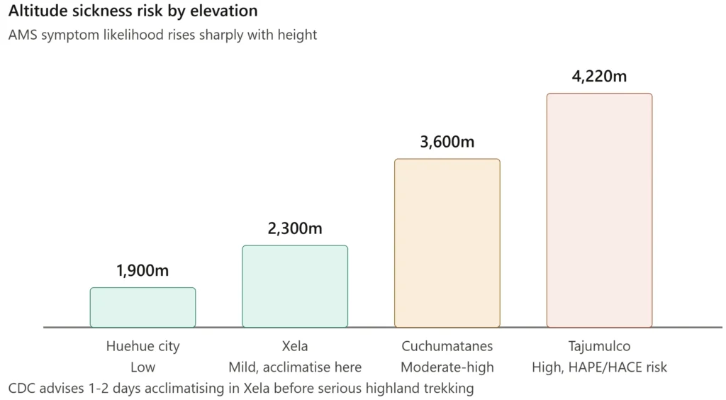
Altitude is the risk most visitors underestimate and in this region it can bite hard. Huehuetenango city sits at 1,900 metres – comfortable enough for most people. The Cuchumatanes push past 3,600 metres. Tajumulco’s summit is 4,220 metres and ascending it from sea level in a day is a genuine medical decision, not just a fitness one. Acute Mountain Sickness brings headaches, nausea and fatigue; the severe forms – HAPE and HACE – require immediate evacuation to Guatemala City. The CDC’s altitude sickness guidance recommends spending one to two days acclimatising in Xela at 2,300 metres before any serious highland trekking. That’s advice I follow personally, not something I’d skip to save a day.
Tap water is not safe anywhere in the region. Bottled or purified water only, full stop. Street food is generally fine if you pick stalls with high turnover and avoid uncooked salads or unpeeled fruit from places where hygiene looks questionable. Diarrheal illness is the most common thing that derails a trip here and it’s almost entirely preventable.
If you’re spending time in the lower elevations of San Marcos – the Pacific slope municipalities like Malacatán or Ayutla – malaria prophylaxis is worth discussing with a travel clinic before you leave home. The highlands of both departments are malaria-free, but dengue and chikungunya are present at lower and moderate elevations year-round, peaking in the rainy season. DEET repellent and long sleeves at dawn and dusk are non-negotiable down there. The WHO’s Guatemala health profile gives current disease burden context if you want the numbers.
Medical facilities in both departmental capitals can handle stabilisation and basic care. Anything serious goes to Xela – about 1.5 to 2 hours from Huehuetenango by car – which has the best private medical provision in the Western Highlands. Guatemala City is five to six hours away. Get comprehensive travel insurance with emergency evacuation cover before you board the plane. This is not a region where you want to be working out logistics in a crisis.
Natural Risks: Volcanoes, Quakes and Landslides
Despite what the names suggest, the volcanoes here aren’t the primary natural hazard. Tajumulco is considered extinct with no Holocene eruptions on record. Tacaná is dormant with minor fumarolic activity and is monitored by INSIVUMEH, Guatemala’s geophysical institute. The real risks on these peaks are hypothermia, disorientation in cloud cove and falls on loose terrain – not lava. Go prepared for cold, wet conditions regardless of what the forecast says at the trailhead.
Earthquakes are a different matter. The entire region sits near the subduction zone where the Cocos and Caribbean plates meet and the highlands have a serious seismic history – the 1976 earthquake devastated communities near Huehuetenango and killed over 23,000 people across Guatemala. Many rural guesthouses and older adobe structures are not built to modern seismic code. Know the drill: drop, cover, hold on. Pick accommodation that looks structurally sound and take note of exits when you check in.
Landslides are the most consistently disruptive natural risk for a traveller on a schedule. The rainy season from May to October brings regular road closures, bridge washouts and occasional village cut-offs, particularly in San Marcos’s Pacific foothills where tropical downpours arrive fast and hard. Even the Inter-American Highway gets blocked. If you’re travelling between May and October, carry extra water, food and cash, build buffer days into your itinerary and treat any delay as likely rather than exceptional.
The Border Zone: When to Stay Clear
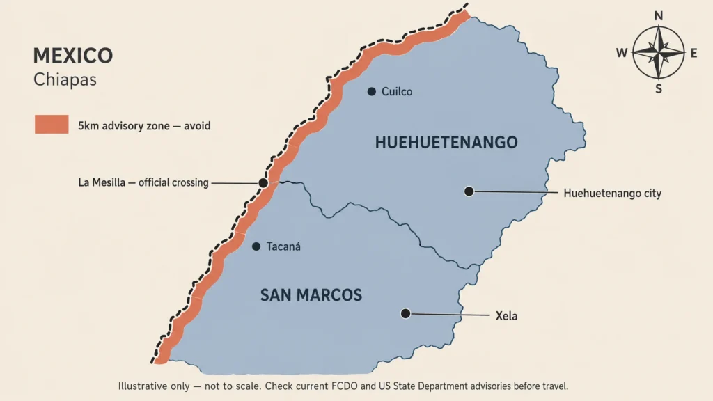
This is the section where the advisory language stops being boilerplate and starts meaning something specific. Both the UK FCDO and the US State Department advise against travel within 5km of the Mexican border in both Huehuetenango and San Marcos. That’s not a general caution – it’s a defined geographic zone and there are concrete reasons for it.
The border corridor running through municipalities like Cuilco, Tacaná and La Mesilla is an active narcotics and migrant smuggling route. Cartel-associated groups operate on both sides of the line. Violence in these areas is linked to trafficking operations rather than opportunistic crime targeting tourists, but the distinction offers cold comfort if you’re in the wrong place. The FCDO also flags the road from La Mesilla into Huehuetenango city itself as an area where criminal activity has been reported. Daylight travel only on that stretch, in a private shuttle or first-class bus, pre-arranged before you reach the border.
The La Mesilla crossing itself – the official overland point into Chiapas used by travellers heading to San Cristóbal de las Casas – is transited daily without incident when you do it right. Cross between 7am and 3pm, have your documents in order, keep a passport photocopy separate from the original and arrange onward transport in advance rather than picking up whoever approaches you at the gate. Reports of officials soliciting small bribes from motorists exist; stay calm, be polite and don’t carry anything across for anyone else under any circumstances. Unofficial pedestrian crossings used by locals are not an option. Ever.
Practical Safety Measures I Swear By
After enough trips through regions like this, a few habits stop feeling like precautions and start feeling like just how you travel. The first is guides on any volcano hike – not because I can’t read a trail, but because a local guide changes the risk profile of the entire outing. Community-based outfits like ASODEST commissions in San Marcos or established operations like Quetzaltrekkers out of Xela know the current situation on those trails in a way no recent blog post does. Register with INGUAT’s tourism assistance line where available before any serious trek.
Cash management catches people out here more than almost anything else. ATMs exist only in Huehuetenango city and San Marcos city and they run out of money or go offline regularly. Carry enough quetzals in small notes to cover your full stay in any remote area, with a buffer. Cards are largely irrelevant outside the departmental capitals.
Cell signal drops to nothing in the Cuchumatanes and on the upper sections of both volcanoes. Download offline maps before you leave – Maps.me and Google Maps both have decent Guatemala coverage offline. For anything involving serious altitude or remote terrain, a personal satellite communicator is worth the rental cost. It’s the kind of thing that feels excessive until the moment it isn’t.
Night travel on intercity roads is the single easiest risk to eliminate. Every official advisory says it, every local will tell you the same thing and the reasoning is straightforward – robbery risk rises sharply, roads are unlit, livestock wander onto the asphalt and drunk drivers are a genuine hazard on mountain bends. Be wherever you’re sleeping before dark. Plan your days around that constraint rather than trying to squeeze it in.
San Marcos and Huehuetenango reward the traveller who arrives prepared. The Cuchumatanes, Tajumulco at sunrise, the Todos Santos market on a Saturday – none of it is inaccessible. It just requires a level of planning that matches the terrain.