
What Comes After the Karakoram? The last article ended where I stood in Rupal Valley surrounded by peaks that made everything else feel insignificant. After months in the mountains, following the thread of the Karakoram Highway, I thought I’d seen Pakistan. I was wrong. Completely wrong.
Leaving those valleys meant leaving a world where geography dominates everything. Down here, in the plains and cities and deserts, history dominates. Different story. Different rules. Different Pakistan.
This isn’t a continuation because the journey continued geographically. It’s a continuation because I realized something crucial: Pakistan isn’t one place. It’s four entirely different countries existing in the same borders, each with it’s own climate, it’s own history, it’s own personality. Some of them don’t even like each other much.
What follows is what I found when I stopped looking up at mountains and started looking at what people built on flat ground.
Punjab – The Heart Of Pakistan
When you mention Pakistan to most travelers, they picture mountains. The Karakoram, the Hindu Kush, the wild north. Nobody’s Instagram is screaming about Punjab. But here’s the thing: Punjab is where Pakistan actually works. It’s the engine. Fifty percent of the country’s population lives here. The money flows here. The power sits here.
Lahore is Punjab’s capital and it’s a city that refuses to make sense. Ancient and modern slamming into each other constantly. I landed here after weeks in the mountains and the transition was violent. Noise, pollution, chaos, but also energy that you can feel crackling through the streets.
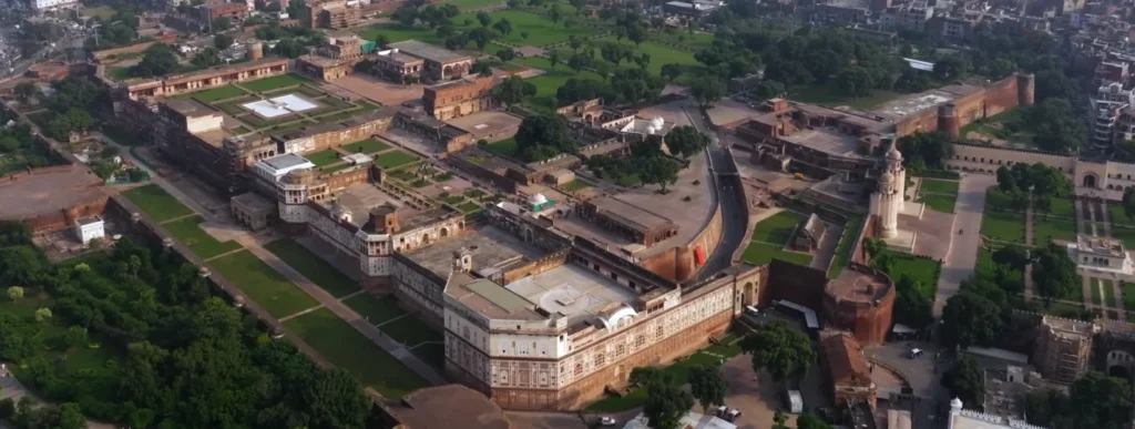
Lahore Fort: Reading History in Brick
Lahore Fort is one of those places where you can physically touch the layers of history. Construction started under Emperor Akbar in 1566, but every ruler after that added something. Aurangzeb modified it. The British “restored” it (meaning they changed things). The Pakistani government has been maintaining it (sort of) since 1947.
I flew my drone over it at 6 AM, before the heat and crowds arrived. The footage shows something you can’t see from ground level: the fort’s geometry. It’s not random. The walls form these perfectly calculated angles. The positioning of gates, courtyards, the sight lines it’s all about control and surveillance. Military architecture, but designed by people who understood beauty.
Walking through actually, the size hits you. The walls are massive. The Alamgiri Gate alone the main entrance, built under Aurangzeb in 1673 is a statement of power that still works four centuries later.
What’s Inside the Fort (The Parts That Matter):
- Alamgiri Gate – Built 1673, main entrance, red sandstone and marble, intricate calligraphy.
- Sheesh Mahal (Mirror Palace) – 17th century, completely covered in mirror inlay work, restored multiple times.
- Diwan-i-Aam – Hall of Common People, where the emperor addressed regular subjects.
- Diwan-i-Khas – Hall of Private Audience, where serious business happened.
- Quadrangles and courtyards – Each one different periods, showing evolution of taste and power.
What struck me wasn’t the individual buildings. It was the progression. You walk through and you’re literally moving through time. The Mughal sections feel different from the British sections. The proportions change. The materials change. It’s like reading someone’s diary written in architecture.
I spent a full day here actually more like 36 hours spread across two days and barely scratched it. Every corner had something. I met a guide named Hassan who’d been working here for 22 years and he told me stories that aren’t in any guidebook. Political prisoners held in certain rooms. Secret escape routes that were sealed. Love affairs between queens and generals.
The official history is one thing. The actual history, the human history, is something else entirely.
Badshahi Mosque: When Arrogance Becomes Beautiful
Right next to the fort literally adjacent sits the Badshahi Mosque, completed in 1673. This wasn’t built as a place of prayer. This was built as a statement. Emperor Aurangzeb wanted to build something so massive, so perfect, so visibly expensive, that it would make clear: this is what real power looks like.
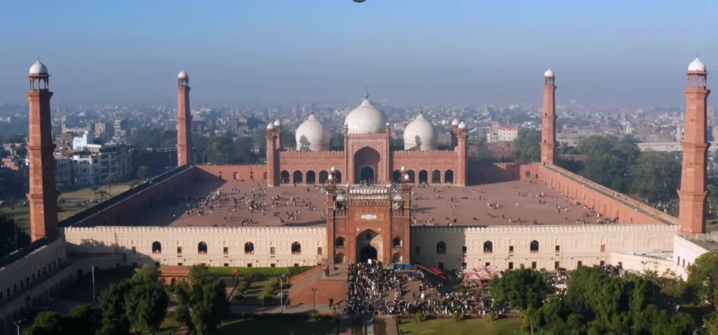
The courtyard can hold 24,000 people for prayer. The prayer hall another 5,000. The domes are white marble that glows in certain lights. The minarets are over 54 meters tall. Everything is calculated to make you feel small.
I watched Friday prayers from a respectful distance (drone footage from above, mostly). Watching 10,000+ people flowing into those spaces simultaneously it’s hypnotic. The coordination, the rhythm. But also the raw humanity of it. People praying, talking, greeting each other. It’s not just architecture. It’s a living, breathing space where people have been coming for 350+ years.
The marble work is insane. The mosque was constructed using red sandstone with marble inlay and there are literally 17 different types of stone used in the inlay patterns. Some of them were imported from Kandahar, others from Kashmir. The cost in today’s money would be hundreds of millions of dollars.
Minar-e-Pakistan: Monument to an Idea
Then there’s Minar-e-Pakistan, which is the opposite of everything around it. It’s not ancient. It’s not Mughal. It’s Pakistan the nation itself, captured in concrete and brick.
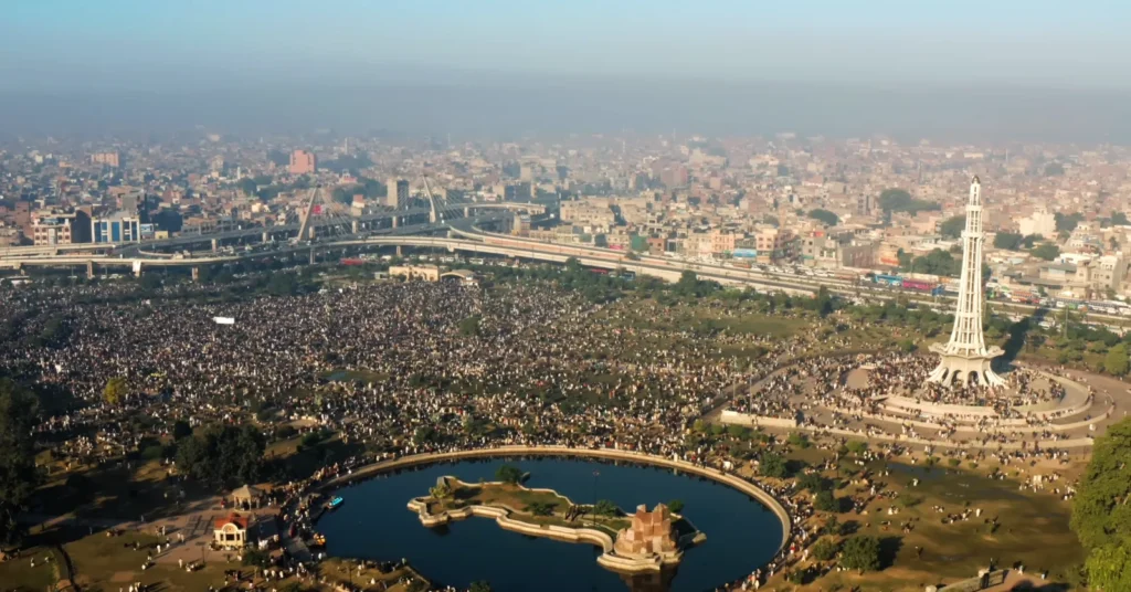
Built in 1961 to commemorate the Lahore Resolution of 1940, this monument marks the moment when the idea of a separate Muslim nation was formally proposed. A Pakistani architect named Nasir-ud-Din Murat designed it 160 meters tall, red brick base with white marble patterns spiraling up.
The park around it is massive. I was there on a Friday and there must have been 50,000 people. Families, couples, kids, old people. It’s not a pilgrimage site like the mosque. It’s just where people come to hang out, to be together, to experience Lahore.
From my drone, it looked like a red needle pushing through the city. From the ground, standing in the massive crowd, it feels different. It feels like a memory being kept alive. Everyone here knows what this place represents. It’s their independence, their nation, their existence as a separate country.
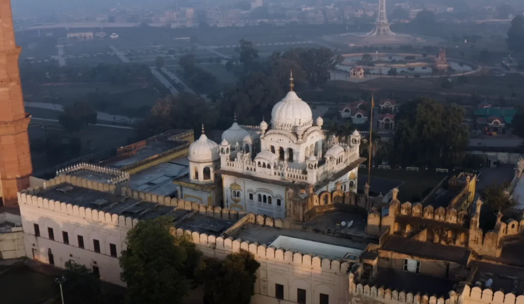
Old City Lahore: Where Things Are Falling Apart (But Still Alive)
Beyond the monuments, the old walled city is where actual Lahore happens. The British called it the “Paris of the East” back when they governed it. Now it’s dense, chaotic, colorful and falling apart in real time.
The streets are narrow some are maybe 3 meters wide, with buildings towering up on both sides. The buildings themselves are incredible. Haveli architecture, traditional mansions with intricate woodwork and tilework. Some are in full restoration. Most are slowly crumbling while people still live in them.
I photographed one haveli that was basically half-ruined. The ground floor was being used as a storage area. The upper floors were occupied by a family that’d lived there for 200 years. When I asked why they didn’t just sell it and move somewhere modern, the owner looked confused. This isn’t just a building. It’s home. You don’t just leave that.
The tilework in these buildings the ceramic inlay patterns is being lost. There are maybe a handful of artisans in Lahore still doing this work. I met one, Mohammad, who’s been doing it for 40 years. He told me he has no apprentices. Nobody wants to learn a dying craft when they can move to Dubai and make 10 times the money in tech.
Crafts Disappearing in Old Lahore:
| Craft | Status | Artisans Left | Market |
| Tilework/Zellige | Endangered | ~5-10 | Almost none |
| Traditional woodcarving | Endangered | ~15-20 | Wedding season only |
| Calligraphy (architectural) | Endangered | ~8 | Government contracts |
| Metalwork inlay | Critical | ~3 | Mostly tourism |
It’s depressing, honestly. These are skills that took lifetimes to develop. They’re disappearing because the economics don’t support them anymore.
Wagah Border: Where Nationalism Performs
About 35 km from Lahore sits Wagah Border, the land border between Pakistan and India. Every afternoon, around 4 PM, something completely absurd happens.
Soldiers from both sides Pakistani Rangers on one side, Indian BSF on the other perform an elaborate ritual. It’s called the Wagah Border ceremony and it’s been happening daily since 1959.
High kicks. Aggressive stares. Chest beating. Choreographed hostility. It’s military theater at it’s most ridiculous and most genuine simultaneously.
I filmed it from both angles ground and drone. From the ground, it’s intense. The soldiers are terrifying. The crowd thousands of them, on both sides is screaming, cheering. The energy is tribal. Nationalistic. Real.
From the drone, it’s absurd. You see the soldiers on one side, then the identical movements on the other side. It’s like watching synchronized swimmers who are trying to intimidate each other. The crowd on the Pakistani side, the crowd on the Indian side. The line between them is just paint.
Is it theater? Yes. Is it genuine? Also yes. That’s what makes it impossible to fully process. The aggression is performed, but the belief behind it isn’t. People genuinely care. They genuinely want their side to “win” this daily performance.
One Pakistani soldier, after the ceremony, told me they practice for weeks to get it right. It’s a point of pride. They want to kick higher, look more intimidating, perform more aggressively than the Indian side. It matters to them.
Intellectually, I understood it was ridiculous. Emotionally, standing there with thousands of screaming people, I felt the tribal pull too. It’s designed to make you feel it.
The Punjab Paradox: How a Region Contains Contradictions
Here’s what nobody tells you about Punjab: it’s where Pakistan’s contradictions are most visible. It’s the most developed region, but also incredibly conservative in pockets. Lahore has startup culture, tech hubs, young people building apps. It also has neighborhoods where women can barely leave their houses.
I stayed in Gulberg, the modern wealthy area, where everything feels almost European. Coffee shops with WiFi, boutique hotels, young couples hanging out openly. Ten kilometers away, in neighborhoods I walked through, the vibe was completely different. Conservative, traditional, women in burqas, men suspicious of a foreigner with a camera.
It’s not that one is real and the other isn’t. Both are real. They just exist in the same city, sometimes even the same neighborhood and they don’t interact much.
I talked to families about this. One family I met the father is a tech entrepreneur, makes good money, sends his kids to international schools. But his sister had an arranged marriage decided by the parents when she was 19. She’s happy now (she said), but the choice wasn’t really hers. The father sees no contradiction. This is just how things work.
Beyond Lahore: The Rest of Punjab
I spent time in Sialkot (industrial, manufacturing hub), Gujranwala (steel and pottery) and Multan (ancient city, but less touristy than Lahore). Each has it’s own character.
Sialkot is where Pakistan makes sports equipment soccer balls, cricket bats, tennis rackets. It’s industrial, working-class, not pretty. But it’s real. This is where actual production happens.
Multan is older than Lahore, with Sufi history and ancient tombs. The city has been continuously inhabited for over 5,000 years, making it one of the oldest cities in South Asia. But it gets almost no tourism compared to Lahore.
Practical Information: Getting Around Punjab
When to Go:
- October to March (temperatures 10-25°C, bearable).
- Avoid May-September (heat is 40-50°C, brutal).
Transportation:
- Flights: Islamabad to Lahore ($30-50, 1 hour).
- Trains: Exist but unreliable
- Buses: Chaotic but work (intercity travel).
- Uber: Works in Lahore, expensive by local standards ($2-5).
Where to Stay:
| Area | Character | Price (Per Night) | Best For |
| Old City | Chaotic, authentic | $10-20 | Experience, danger |
| Gulberg | Modern, upscale | $40-80 | Comfort, safety |
| Mall Road | Middle ground | $20-40 | Balance of both |
| Downtown | Tourist zone | $15-30 | Convenience |
Costs:
- Good meal: $2-4.
- Street food: $0.50-1.
- Hotel (budget): $15-25.
- Hotel (decent): $35-60.
- Getting around: $1-3 per trip.
KPK & Northern Balochistan: Mountain Routes, Ancient Forts and the Edge of Civilization
The Drive South: Leaving Punjab Behind
The Pakistan-Afghanistan border doesn’t announce itself clearly. There’s no dramatic moment where you cross a line and suddenly you’re in a different world. Instead, it happens gradually. The landscape shifts. The cities change character. The air feels different. You’re entering Khyber Pakhtunkhwa (KPK) and things are older, wilder and more complicated.
The drive from Lahore south toward Multan, then into KPK, is roughly 500 km depending on your route. I drove it partly by road (National Highway N-5), partly by smaller routes to hit the places most tourists miss.
Peshawar: The Frontier City That’s Trying
Peshawar is the capital of KPK and one of the oldest cities in Pakistan. It’s been repeatedly destroyed and rebuilt Alexander the Great’s army was here, various dynasties conquered it, the British ruled it, now it’s Pakistani.
The problem with Peshawar is security. For years it wasn’t safe for tourists. Militant attacks, kidnappings, general danger. Things have improved significantly in the last 5-10 years, but the reputation lingers. When I told people I was going to Peshawar, I got worried looks.
But when I got there, it was fine. Busy. Intense. Not comfortable for everyone. But fine.
The Peshawar’s Grand Bazaar is where things get interesting. It’s been operating for centuries as a trading hub. Officially it’s called Qissa Khwani Bazaar (The Storytellers’ Bazaar) and the name comes from when merchants would tell stories to entertain customers while waiting for deals to close.
The bazaar is narrow streets, packed with shops selling everything spices, textiles, weapons (actual weapons, semi-legally), electronics, carpets. It’s sensory overload. I went in late afternoon with a local guide (strongly recommended) and it was chaos. Controlled chaos, but chaos.
One shop owner invited me for tea. We sat on the floor, drank chai and he told me his family’s been running that shop for 80 years. His grandfather started it, his father ran it, now he runs it and his son will probably run it. It’s not a fortune. Just enough to live. But there’s pride in it.
Kohat: The Bridge Between Worlds
Heading south and east from Peshawar, you hit Kohat. This is where the landscape starts changing. You’re moving out of the Peshawar Valley into more mountainous terrain. The climate shifts. The culture shifts.
Kohat’s claim to fame is the Kohat Pass, which connects the Peshawar Valley to the Bannu Valley. Historically this was a critical military route. Control Kohat Pass and you controlled movement between north and south.
I hiked up near some of the old fortifications in the pass area. There are remains of military installations from different periods British era mostly, but older structures too. Nothing dramatically intact, but you can see where walls were, where gates stood, where lookouts monitored the route below.
The view from up there is stunning. You can see for 50+ km across valleys and ridges. In military terms, that means you can see enemies coming a long time before they arrive.
Ancient Forts of the Border Region
This is where the real historical archaeology starts getting interesting. Northern Balochistan and southern KPK are littered with ancient fortifications some are Greek (from Alexander’s time), some are medieval Islamic, some are just ancient beyond dating.
Fort Bala Hisar, overlooking Peshawar, is one of the oldest and most strategically important. It’s been fortified and rebuilt so many times that pinpointing when it was originally built is nearly impossible. Definitely pre-Islamic. Probably Greek or Parthian. Definitely continuously used for military purposes until recently (the British used it, then Pakistan).
What’s remarkable about these forts isn’t usually the architecture most are damaged or poorly preserved. It’s the locations. Every single one is positioned perfectly. They control supply routes, communication lines, river crossings. Someone with serious military knowledge designed these.
Northern Balochistan & KPK Ancient Sites:
- Fort Bala Hisar (Peshawar) – Likely Greek origin, continuously fortified.
- Ancient city remains (various) – Pre-Islamic trading posts.
- Mountain passes – Strategic locations with remains of fortifications.
- River crossings – Historic military positions now abandoned.
I spent time at a few of these sites, including some that aren’t officially tourist destinations. Local villagers would tell me the history as they knew it stories passed down, not necessarily accurate, but closer to lived experience than textbooks.
One old man near Kohat told me his great-grandfather’s great-grandfather fought at these forts. He didn’t remember the details, but he knew the stories mattered. That connection to land and history, even vague, is everywhere in this region.
The Karakoram Highway and Northern Routes
From KPK, if you head north, you enter the territory I covered in the previous article the Karakoram, the valleys, the mountains that made everything else feel insignificant.
The journey south from those mountains into the plains and cities is a complete shift. Going north from here back into the mountains would reverse that.
What’s interesting about KPK is that it’s the bridge. It’s not quite the chaos of Lahore, not quite the wilderness of the north, not quite the desert of the south. It’s transition territory.
Practical Information: KPK & Northern Balochistan
When to Go:
- April to October (temperatures 15-35°C).
- Avoid winter in the north (can get snowy).
Security:
- Peshawar is generally safe now, but check current situation.
- Avoid going out at night solo.
- Use local guides in bazaars.
- Some border areas restricted check current rules.
Transportation:
- Flying is expensive but fast (Lahore to Peshawar ~$50, 1.5 hours).
- Driving takes 8-10 hours, scenic but slow.
- Local transport exists but unreliable.
Where to Stay:
| Area | Character | Price/Night | Notes |
| Peshawar | City | $20-50 | Try Pearl Continental or similar |
| Kohat | Small town | $10-20 | Basic but fine |
| Border regions | Remote | $5-15 | Very basic, local guesthouses |
Costs:
- Meals: $2-4.
- Guides: $15-30/day.
- Guesthouses: $10-30.
- Local transport: $0.50-2.
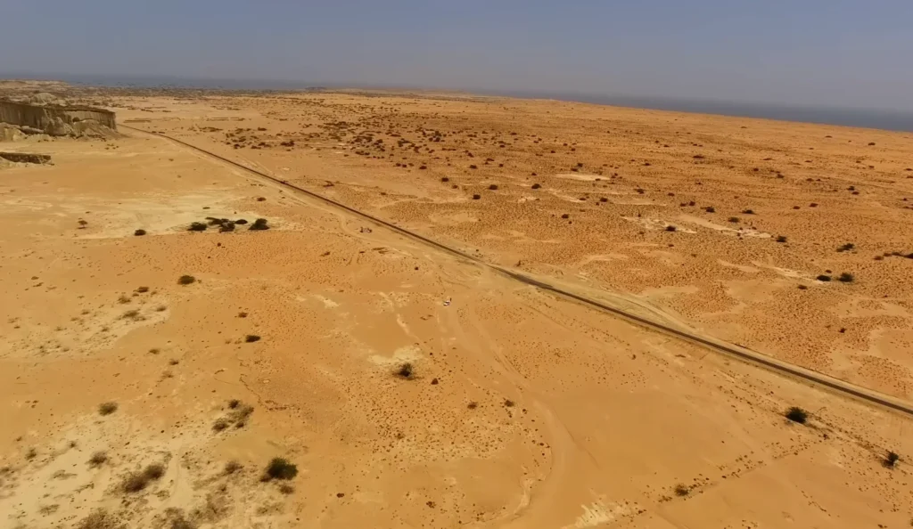
BALOCHISTAN: Deserts, Coastlines, Mud Volcanoes and a Region That Wants to Be Left Alone
Balochistan is the part of Pakistan that most Pakistanis haven’t really explored. It covers 43% of the country’s land but has only 5% of the population. It’s massive, sparsely populated and culturally distinct enough that it sometimes feels like a different country entirely.
There are security concerns here too militant activity, tribal governance in some areas, infrastructure that’s literally crumbling. But if you’re careful, do research and accept the risk, there’s nowhere else in Pakistan like it.
The province is split roughly into three zones: the northern mountains (connection to KPK), the central desert plateau and the southern coast. Each is radically different.
Quetta: The Mountain City in the Middle of Nowhere
Quetta is Balochistan’s capital, sitting at about 1,700 meters elevation in the middle of the province. It’s a city that feels entirely out of place surrounded by desert and mountains, but with relatively modern infrastructure and a busy bazaar.
The city isn’t ancient. It’s mainly a British creation they built it as a military garrison and administrative center. The British established Quetta as a cantonment in 1887, using it as a forward base for the British Raj.
What I found in Quetta was a place genuinely trying to develop, genuinely trying to be normal, while existing in one of Pakistan’s most troubled regions. The bazaar is active. People are doing business. Schools are operating. It’s life happening despite difficult circumstances.
The food is different here. Baloch food is heavier, different spice profile. Meat-heavy (Balochistan is pastoral, herding culture). Less refined than Punjabi food, but more honest somehow.
The Mud Volcanoes: Earth Doing Something Strange
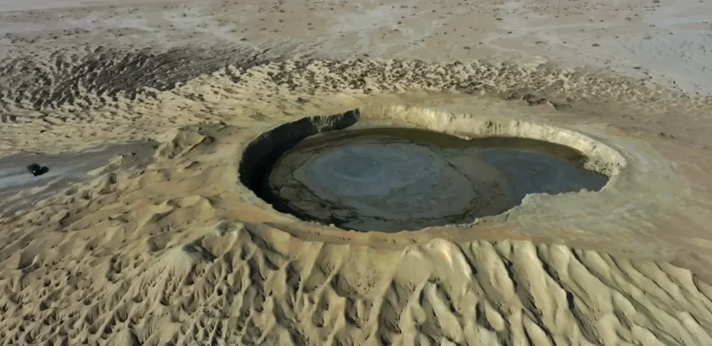
One of Balochistan’s strangest attractions is the mud volcanoes. These aren’t real volcanoes they’re geological formations where underground pressure forces mud and gases up through the surface, creating cone-like structures.
The Balochistan Mud Volcanoes are among the most active in the world. I drove out to see them (roughly 3 hours from Quetta) and they’re genuinely otherworldly.
The landscape looks alien. The ground is cracked mud, ancient dried clay. You walk on what looks solid and suddenly it shifts slightly the ground is still semi-active, still moving. The mud is warm. Gases are being released constantly, creating a subtle hissing sound everywhere.
The volcanoes themselves are scattered across the landscape like random hills, except they’re made of mud and they’re actively expelling gases and occasionally liquid mud. I got drone footage that made them look like miniature versions of real volcanoes.
Local people told me these formations have been active for thousands of years. Some of these mud volcanoes are mentioned in ancient texts, though pinpointing which ones is difficult.
The Balochistan Coast: Where Desert Meets Sea
Balochistan has a long Arabian Sea coastline, but it’s barely developed. The main coastal city is Gwadar, which has been in the news because of the China-Pakistan Economic Corridor development projects.
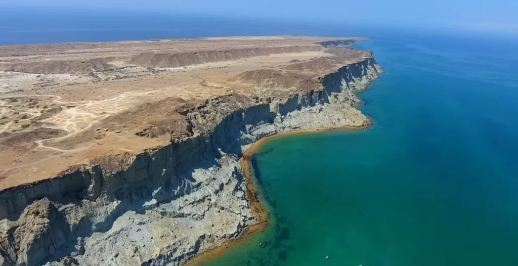
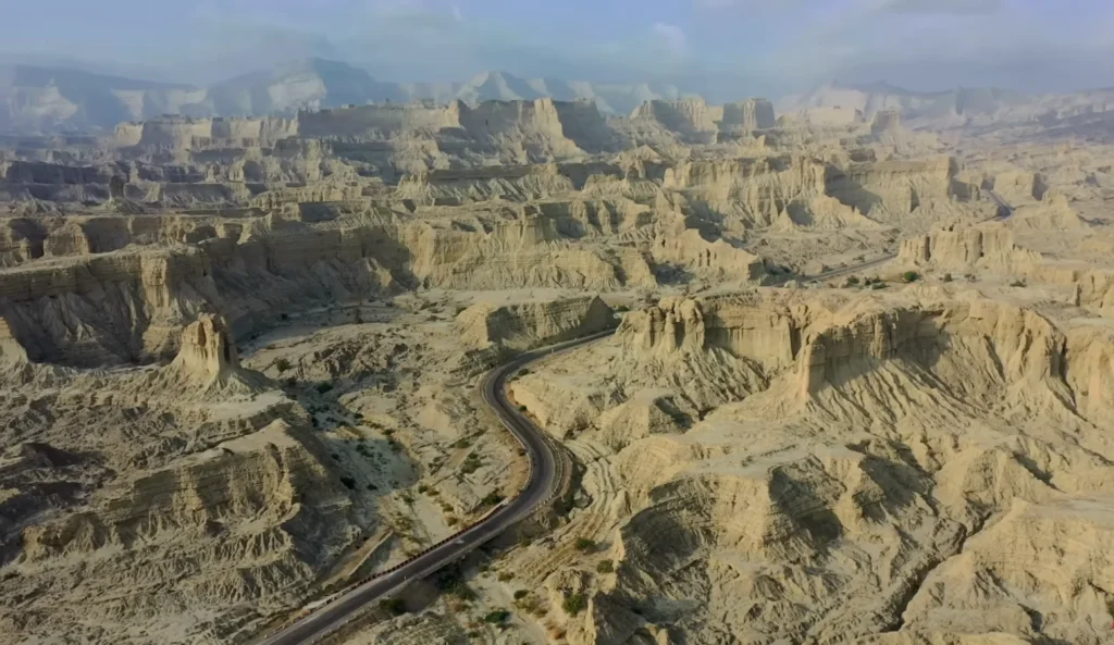
I drove to the coast (about 6 hours from Quetta) through pure desert landscape. Long stretches of absolutely nothing. The Makran Coastal Highway runs along here and it’s one of the most desolate drives I’ve done anywhere.
When you finally reach the coast, it’s stunning. Turquoise water. Rocky cliffs. Beaches that see maybe one visitor a month. It’s beautiful precisely because it’s undeveloped, untouched, uncomfortable to get to.
The people who live on this coast the Baloch, mostly have been here for centuries. They’re seafarers by tradition, fishermen, traders. The sea was their highway to Oman, to India, to the rest of the Indian Ocean world.
Now it’s becoming a military and economic development zone because of Gwadar Port. The Chinese are investing heavily. Pakistan’s building infrastructure. Everything’s changing rapidly and the locals aren’t entirely happy about it.
One fisherman told me his family had fished these waters for 400+ years. Now he’s being asked to move because the port development needs the land. He doesn’t want compensation. He wants his fishing grounds back. He’s probably not getting that.
The Baloch People and Tribal Structure
Balochistan is organized tribally in many areas. The Baloch are an ethnic group with their own language, culture and history separate from the rest of Pakistan. There’s been ongoing tension between the Baloch independence/autonomy movements and the Pakistani federal government.
This is sensitive territory to write about. I’m mentioning it because it’s important context, but I’m aware I’m an outsider looking in at something complicated.
What I observed: strong sense of Baloch identity, distinct from Pakistani identity. Some towns flew Baloch flags. Some areas had visible military/security presence. People were friendly but sometimes wary of outsiders partly because of the tensions, partly just because outsiders are rare here.
One conversation that stuck with me: a tea shop owner in a small town explained that Baloch people feel abandoned by Pakistan. No investment, no development, no opportunities. Young people leave. The region feels neglected. Whether that’s accurate or a matter of perspective, I can’t say. But that was the feeling I got consistently.
Desert Landscape and Nomadic Life
Inland Balochistan is mostly desert plateau semi-arid, sparse vegetation, extreme heat in summer. The people here traditionally have been pastoral nomads, moving herds of goats and sheep across the landscape.
I spent time in a small village where a family invited me to observe their daily life. They keep goats, move seasonally to find water and grazing. It’s hard work. The margins are tight. If a drought comes (which happens periodically), people go hungry or lose everything.
Climate change is making this harder. Droughts are more frequent. Water sources are drying up. Traditional pastoralism is becoming economically unviable. Young people don’t want to do it anymore.
But the older generation they know this land intimately. They can read weather patterns, find water sources that aren’t obvious, navigate by stars and landscape features. It’s knowledge that’s being lost because the economic conditions that supported it have changed.
Practical Information: Balochistan
IMPORTANT – Security Considerations:
Balochistan has real security issues. Militant activity, kidnappings, robbery. This isn’t theoretical. Before going, check current situation with your government, travel advisories, etc.
When to Go:
- October to March (temperatures manageable, 15-30°C).
- Never in summer (40-50°C+, brutal).
Getting Around:
- Quetta is the main hub, fly from Islamabad or Lahore ($50-70).
- Internal travel is by road, distances are huge.
- Hire a local guide or join organized tours (safer).
- Check security situation daily.
Transportation:
- Quetta to mud volcanoes: 4WD rental recommended ($30-50/day).
- Quetta to coast: 6-8 hours driving.
- Public buses exist but rarely used by tourists.
Where to Stay:
| Location | Type | Price/Night | Security |
| Quetta | City | $20-40 | Reasonable |
| Small towns | Guesthouses | $10-20 | Varies |
| Coastal areas | Basic | $15-25 | Check first |
Costs:
- Meals: $2-4.
- Guesthouses: $10-30.
- Guides: $25-40/day.
- Fuel/transport: $30-50/day.
What to Bring:
- Sunscreen (strong).
- Water (lots).
- Hat/head covering.
- Respectful clothing.
- Current travel insurance.
- Offline maps.
Safety Tips:
- Don’t travel alone.
- Avoid night driving.
- Check in with authorities.
- Have local contact numbers.
- Be prepared to change plans.
Sindh: Where Pakistan’s Oldest Civilizations Live and Breathe
The Shift: Entering Sindh
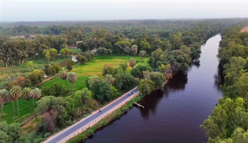
Coming from Balochistan into Sindh feels like entering a completely different geological and cultural zone. Balochistan is harsh desert, mountains, sparse. Sindh is defined by water. The Indus River cuts through it and everything follows the river.
This is the Indus Valley, where some of humanity’s oldest civilizations flourished. The Indus Valley Civilization dates back to 3300 BCE, making it contemporaneous with ancient Egypt and Mesopotamia. For nearly 2,000 years, this civilization was the most geographically extensive in the ancient world.
The drive from Quetta to Sukkur takes about 12 hours through landscape that shifts gradually from desert to river valley. By the time you hit Sukkur, the climate feels different. Greener. Humid. Alive.
Sukkur: A City on the River
Sukkur sits on the Indus River and has been a major city for centuries. The river here is wide, powerful and historically it was the main crossing point between northern and southern Sindh. Control Sukkur and you control the Indus.
The Sukkur Barrage, built by the British in 1932, is a massive irrigation structure. It’s not beautiful, but it’s impressive. The scale of it the gates, the engineering it’s designed to manage water flow for agricultural irrigation across millions of acres.
What I found interesting wasn’t the barrage itself but standing on it and watching the Indus flow beneath. This river has been the lifeblood of this region for 5,000+ years. Every kingdom, every civilization, every empire that wanted to control Sindh had to control the Indus.
The Rohri Hills and Ancient History
Just across from Sukkur, accessible by ferry, are the Rohri Hills. These limestone hills rising from the flat valley are dotted with ancient caves and archaeological sites.
I spent a full day exploring these hills. The cave system is extensive some natural caves, some clearly carved out by humans. How old? That’s complicated. Some are probably pre-Islamic (could be 1,000+ years old), but dating caves is difficult.
What’s clear is that people have been living here, using these caves, for a very long time. The position makes sense high enough to see approaching threats, close enough to the river for water, caves for shelter. It was a defensible, livable location.
Local guides told stories about the caves some supposedly used as meditation caves by Sufi saints, others as military positions. Which stories are historically accurate versus folk tradition, I can’t verify. But the presence of these sites, the layers of usage, is undeniable.
[IMAGE: Ancient fortification ruins in valley – labeled “Image 5: Archaeological site with stone structures”]
Hyderabad: The City That Refuses to Be Modern
South of Sukkur, about 140 km, is Hyderabad not to be confused with Hyderabad in India. This is Sindh’s second city, sitting on the Indus.
Hyderabad was founded in 1768 by the Talpur dynasty, but the city has ancient roots. The area has been inhabited for thousands of years because the Indus location made it defensible and economically viable.
The old city is where things get interesting. Narrow streets, traditional architecture, massive havelis (traditional mansions) with intricate tilework and carved wooden elements.
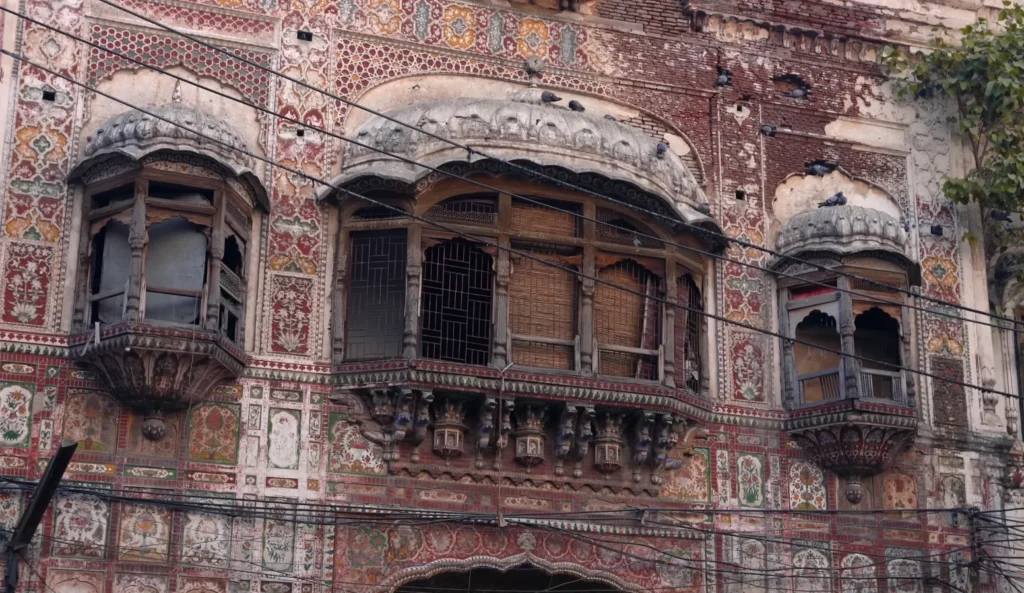
One haveli I photographed extensively was partly in ruins, partly occupied. The owner, an old man named Mir Ahmed, invited me for tea. He told me the building is 300 years old, built by his ancestor who was a wealthy merchant. The family has lived there continuously since.
The building is falling apart. The roof leaks. The walls are cracking. He could sell it for a fortune to a developer the location is prime for modern development. But he won’t. “This is not just a building,” he told me. “This is where my family exists.”
That sentiment keeps showing up throughout Pakistan this unwillingness to abandon old places even when it’s economically irrational. There’s a value assigned to continuity that Western thinking doesn’t quite capture.
The Tile Work and Craftsmanship
The decorative tilework in Hyderabad’s old havelis is stunning. Similar to what I’d seen in Lahore, but different style. The colors are more vibrant here blues, greens, yellows, terracotta. The patterns are geometric and floral.
I met a tile artisan named Mohammad Hasan who was doing restoration work on one of the old havelis. He told me he learned the craft from his father, who learned from his father. It’s a family trade that goes back generations.
But same story as everywhere else no one’s learning anymore. His son is studying engineering. His nephews are in tech. The craft is dying not because it’s bad, but because the economics have changed. You can make more money faster in other fields.
Mohammad showed me the tools he uses simple, ancient tools. Chisels, hammers, levels. He can cut and set tiles by hand, creating patterns that would take a computer-controlled machine hours to design. It’s skill that’s being lost.
The Indus River Culture
Sindh’s entire culture revolves around the Indus. The river is more than a geographic feature it’s spiritual, economic, cultural. The Indus Delta, where the river meets the sea, used to be one of the most biodiverse regions in the world.
The Indus has been domesticated almost completely by dams and irrigation. The Sukkur Barrage, the Guddu Barrage, multiple others upstream. This has been devastating for the delta ecosystem. The river now carries a fraction of the water it historically did.
I talked to fishermen in small villages along the river. They told me the fish populations are a fraction of what they were 20-30 years ago. The river level is lower. Salinity in the delta has increased because less freshwater reaches it.
This is an environmental story that doesn’t get much international attention but is catastrophic for the people living here.
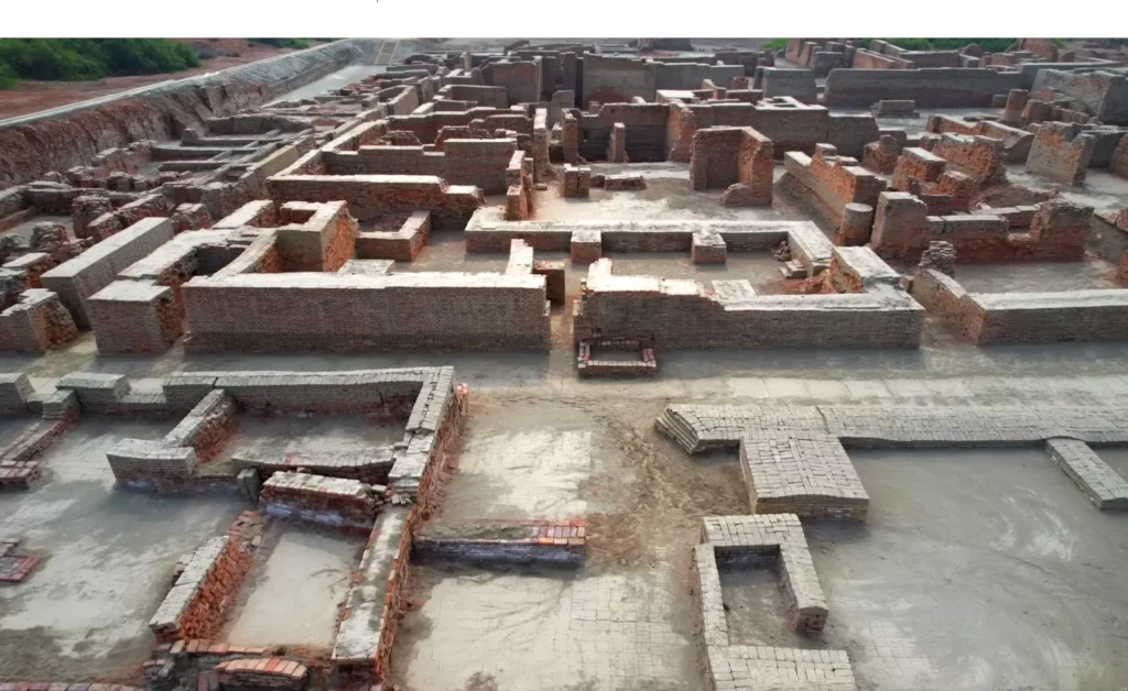
Mohenjo-daro: The Ghost City
About 80 km south of Hyderabad sits Mohenjo-daro, one of the most significant archaeological sites in the world. It’s a preserved city from the Indus Valley Civilization, dated to around 2600-1900 BCE.
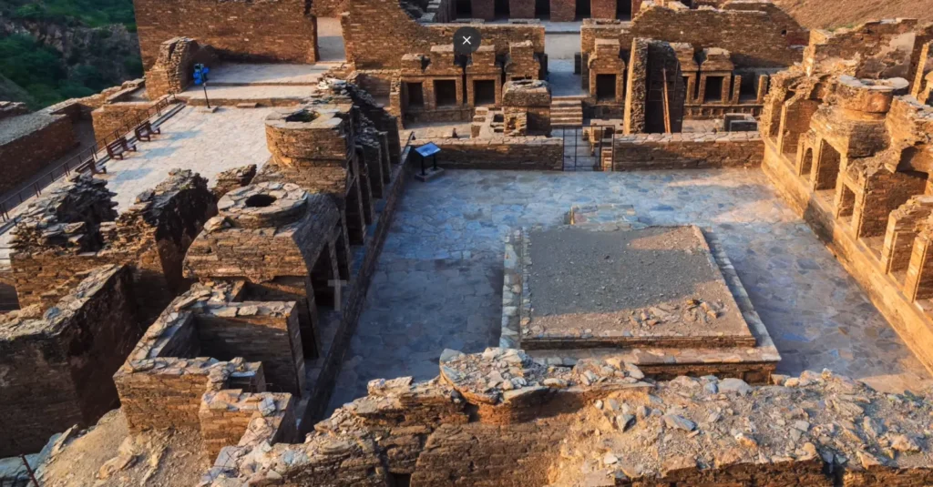
The site is massive 143 hectares of excavated structures. Walking through it is genuinely disorienting because you’re walking through a city that was abandoned roughly 3,500 years ago. The streets are still there. The buildings (or their foundations) are still there. You’re literally walking where people walked 3,500 years ago.
What makes Mohenjo-daro incredible is that we don’t know what happened to it. The civilization collapsed around 1900 BCE. The reasons are debated climate change, floods, invasion, disease. Nobody knows for certain.
The archaeological evidence is remarkable though. The city was organized on a grid system not random, but planned. There was sophisticated drainage. Evidence of craft specialization (different areas for different trades). A standardized system of weights and measures. The Indus script, which we can’t yet read.
The mystery is maddening. We have physical evidence of a sophisticated civilization, but we can’t read their language. We can guess at their social structure from artifacts, but we can’t be certain. It’s like having half a conversation.
Harappa and the Indus Valley Sites
Related to Mohenjo-daro is Harappa, another major site from the Indus Valley Civilization, located north of Mohenjo-daro. I didn’t make it to Harappa on this journey (time constraints), but it’s equally significant.
The Indus Valley Civilization covered an area larger than Egypt or Mesopotamia combined, with hundreds of sites scattered across modern-day Pakistan and India. Mohenjo-daro and Harappa are the two largest excavated urban centers.
What’s frustrating is that these sites aren’t receiving adequate funding or protection in Pakistan. Mohenjo-daro has been on the UNESCO World Heritage List since 1980, which provides some protection, but the site is vulnerable to erosion, water damage and general deterioration.
The government has preservation projects ongoing, but resources are limited. It’s a low priority compared to immediate development needs. Understandable, but tragic. We have access to one of humanity’s greatest mysteries and we’re letting it crumble.
Sindhi Culture: Music, Food and Language
Sindh has a distinct culture separate from the rest of Pakistan. The Sindhi language, the food, the music it’s all unique to this region.
Sindhi music has Sufi influences mixed with folk traditions. The instruments are unfamiliar to me the alal, the ektaro (a single-stringed instrument), various drums. The rhythms are complex, the lyrics often poetic.
I heard musicians performing in Hyderabad’s old city, playing traditional instruments, singing in Sindhi. The music felt ancient, like it had been played the same way for centuries.
Sindhi food is different from Punjab. Rice-heavy instead of wheat-heavy. Lots of lentils, fish from the river, simple preparations. The flavors are lighter, less spiced-forward than Punjabi cuisine.
One thing that struck me: there’s a sense of Sindhi identity that’s distinct from Pakistani identity. Similar to what I felt in Balochistan with the Baloch people. Sindhi is an ethnicity, not just a regional identity. The language is spoken at home. The culture is maintained. There’s pride in being Sindhi first, Pakistani second.
This isn’t separatism necessarily, but it’s a strong cultural continuity that suggests these regions were artificially unified by the British and then inherited as unified by Pakistan.
The Crisis: Water, Climate and Displacement
Sindh is facing a water crisis. The Indus is being over-extracted upstream (by Punjab and KPK) and downstream Sindh isn’t getting enough water. The delta is dying. Agricultural land is becoming saline. Fishing communities are losing their livelihoods.
The Indus Waters Treaty of 1960 theoretically allocates water between Pakistan and India, but the Pakistani allocation is increasingly contested. Upstream provinces want more. Sindh claims it’s being shortchanged.
This is a real crisis with real consequences. Farmers losing crops. Fishermen losing fish. Entire communities facing displacement.
I met one community near the delta that was literally relocating the land they’d lived on for generations was becoming unsuitable for farming or fishing. The provincial government was offering resettlement. Most people didn’t want to leave. They wanted their land back. They’re probably not getting that.
Practical Information: Sindh
When to Go:
- October to March (temperatures 20-30°C, humidity manageable).
- Avoid April-September (40-50°C, very humid, uncomfortable).
Getting Around:
- Fly Islamabad/Lahore to Sukkur or Hyderabad ($60-80, 2-3 hours).
- Road travel between cities is long but possible.
- Local buses exist but are uncomfortable for tourists.
Where to Stay:
| Location | Type | Price/Night | Notes |
| Sukkur | Hotels | $20-40 | Basic but clean |
| Hyderabad | Hotels/Guesthouses | $15-35 | Old city is atmospheric |
| Mohenjo-daro | Limited | $15-30 | Stay in nearby Larkana |
| Small towns | Guesthouses | $10-20 | Very basic |
Transportation:
- Sukkur to Hyderabad: ~2 hours by car ($3-5).
- Hyderabad to Mohenjo-daro: ~2.5 hours ($3-5).
- Local taxis/rickshaws: Cheap, negotiate rates.
Food & Costs:
- Meals: $2-4.
- Street food: $0.50-2.
- Hotels: $10-40 depending on quality.
- Guides: $20-30/day.
- Archaeological site entry: $2-5.
What to See:
| Site | Distance | Time Required | Difficulty |
| Sukkur Barrage | 0 | 2-3 hours | Easy |
| Rohri Hills | 10 km | 4-6 hours | Moderate |
| Hyderabad old city | 140 km | 1-2 days | Easy |
| Mohenjo-daro | 220 km | Full day | Easy (walking around) |
| Hyderabad shrines | 140 km | 1-2 hours | Easy |
Things to Know:
- Hyderabad is less touristy than other major cities infrastructure is basic.
- Guides are helpful (many sites lack explanatory material).
- Bring water, sun protection.
- Photography rules vary ask before shooting.
- Sindhi hospitality is genuine (people will offer chai, food).
- Learn basic Sindhi pleasantries if possible people appreciate the effort.
The Human Element: Why Sindh Matters
Here’s what I realized traveling through Sindh: this region contains layers of history that most of Pakistan doesn’t acknowledge or understand. The Indus Valley Civilization. Islamic medieval kingdoms. Sufi saints and spiritual traditions. Colonial British period. Modern Pakistan.
All of these exist simultaneously in Sindh. They’re not separated chronologically they overlap, influence each other, create something that’s genuinely unique.
And yet Sindh feels like the forgotten region. Not the dramatic wilderness of Balochistan. Not the modern development of Punjab. Not the adventure-tourism appeal of KPK and the north.
It’s a region that requires slow travel, conversation, willingness to sit with history that’s incomplete and mysterious. You won’t get Instagram moments here (though the photography opportunities are great). You’ll get conversations with old men in tea shops. You’ll get glimpses of crafts that are disappearing. You’ll get haunted by the mystery of Mohenjo-daro.
I met an archaeologist in Hyderabad named Dr. Aslam who’s been studying Sindh’s sites for 30 years. He told me that we’re probably losing archaeological knowledge every year as sites erode, as funding doesn’t materialize, as younger generations don’t enter the field.
“We’re running out of time to understand our own history,” he said. It’s a sentiment that stuck with me.
Reflection: Four Regions, One Country
I’ve now traveled through four regions of Pakistan, each completely different. Punjab with it’s dense population, urban development and constant motion. KPK with it’s mountain geography, historical significance and complicated politics. Balochistan with it’s vast emptiness, fierce independence and untamed character. Sindh with it’s ancient civilizations, water-dependent culture and enigmatic history.
They share a country, but they’re genuinely different places with different cultures, different histories, different futures.
If you’re visiting Pakistan, avoid treating it as one monolithic destination. Spend time in each region. Let them confuse you. Let them challenge your expectations. The country only makes sense when you see it as a collection of distinct places that happen to share a border.
That’s what the Karakoram taught me initially (focus, isolation, clarity). These four regions taught me something different: complexity, contradiction, the impossibility of single narratives.
Pakistan is all of them. None of them alone.
CONCLUSION: What I Learned Traveling Pakistan’s Regions
Coming down from the mountains into these regions, I expected clarity. I expected the Karakoram journey to have shown me Pakistan’s soul and the regional journeys to fill in details.
Instead, I found that Pakistan doesn’t have a single soul. It has four. Maybe more.
Each region has it’s own history, extending back centuries or millennia. Each has it’s own culture, it’s own language, it’s own way of being. The British unified them administratively. Partition divided them politically. Pakistan attempted to unite them as a nation-state.
But the unity is recent and fragile. The divisions are ancient and deep.
As a traveler, this is what makes Pakistan so compelling. You’re not visiting a single narrative. You’re witnessing the collision and coexistence of multiple narratives. Some cooperate. Some conflict. Some ignore each other.
Understanding Pakistan requires accepting that you’ll never fully understand Pakistan. The contradictions don’t resolve. The mysteries don’t solve completely. You just have to sit with the complexity.
That’s both the frustration and the beauty of it.A Regional Journey Through Four Distinct Worlds