
The plane banked hard. I was in a small prop aircraft — the kind where you can see the engine housing from your window seat and the whole fuselage shakes on descent. Below, nothing but green. Coconut palms, dense vegetation, a runway that looked way too short.
That’s the thing about arriving in the Philippines outside Manila. You don’t get the gleaming international terminal experience. You get this. A turboprop cutting through humid air, touchdown on a regional strip, and suddenly you’re standing on tarmac wondering where immigration even is.
I’d flown into one of the smaller airports deliberately. Wanted to skip the Metro Manila chaos on arrival. Good call? Debatable. But it set the tone for what this trip would be: not curated, not comfortable, definitely not boring.
The Philippines has over 7,600 islands — that number went up recently when they did a proper recount using satellite imaging. Used to be 7,107. Turns out geography isn’t as fixed as we assume. Neither were my plans.
First night was a blur. Literally. Highway lights streaking past, unfamiliar signage, the back of a van taking me to accommodation I’d booked three hours earlier. There’s a specific kind of exhaustion that hits when you land somewhere new after dark. You can’t orient yourself. The city — or town, or whatever this was — exists only as headlights and shadows.
I didn’t mind. Tomorrow would make sense of it.
Getting Around: Tricycles, Ferries and the Beautiful Chaos
Filipino transportation deserves its own documentary. I’m serious.
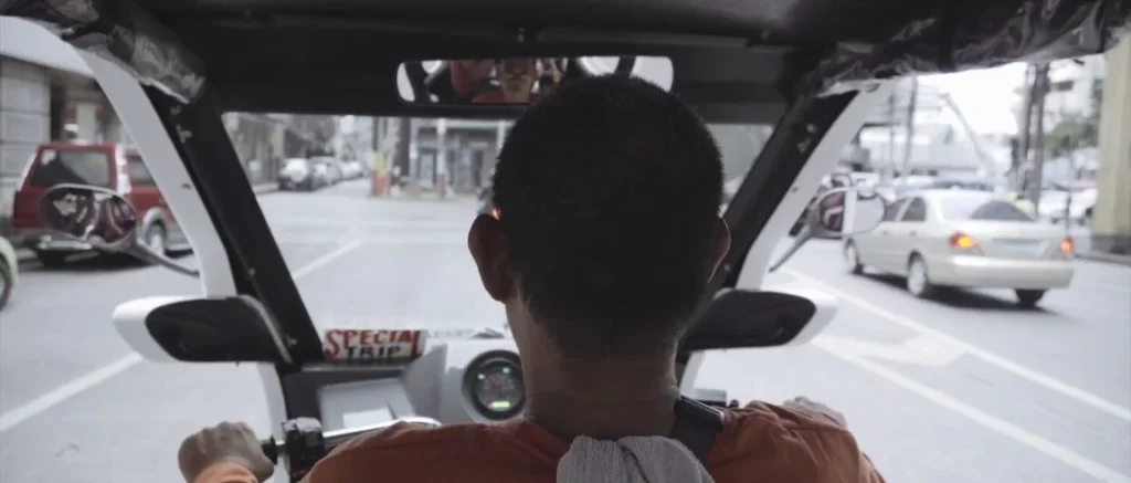
I defaulted to the tricycle, not the one that toddlers ride but a motorcycle with a covered sidecar that has been welded into it. You pull one over, negotiate a fare (or not, depending on your energy levels) and then you are weaving through traffic at a pace that would be reckless if you did not know that everybody is doing the same thing.
The one I was riding on most had SPECIAL TRIP that was written on the dash. The chauffeur was clad in an orange shirt. We did not chat, my Tagalog being non-existent except salamat, but he brought me to where I had to be, and there ends the deal.
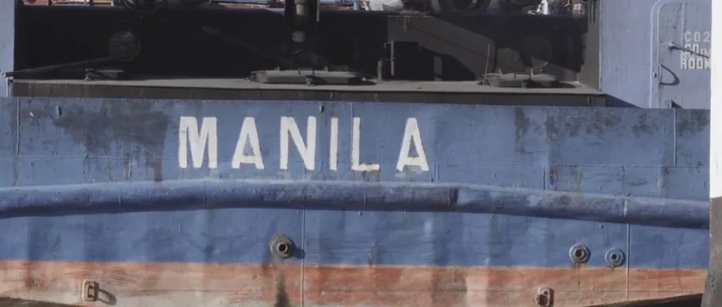
Then there are the ferries. The inter-island ones. I took a vessel with “MANILA” painted on its hull in white block letters, the blue paint underneath chipped and rusted in that way working boats always are. These aren’t cruise ships. They’re transport functional, unglamorous, essential.
Quick Breakdown: How I Got Around
| Mode | Used For | Cost Range (PHP) | Vibe |
| Tricycle | Short urban hops | 20-100 | Chaotic, fun |
| Jeepney | Longer city routes | 13-25 | Cramped, cultural |
| Inter-island ferry | Between major islands | 500-2,000+ | Slow, scenic |
| Domestic flight | Long distances | 1,500-5,000 | Efficient |
| Hired van | Group transfers | Negotiated | Comfortable |
The jeepney system, by the way, has roots in post-WWII American military jeeps that Filipinos repurposed and decorated. They’re being phased out now for modernized versions — emission standards — but you still see the classic ones everywhere outside Manila. Chrome horses on the hood. Religious decals on the windshield. Standing room only in the back.
Bohol: The Hills That Turn Chocolate and a River Through the Jungle
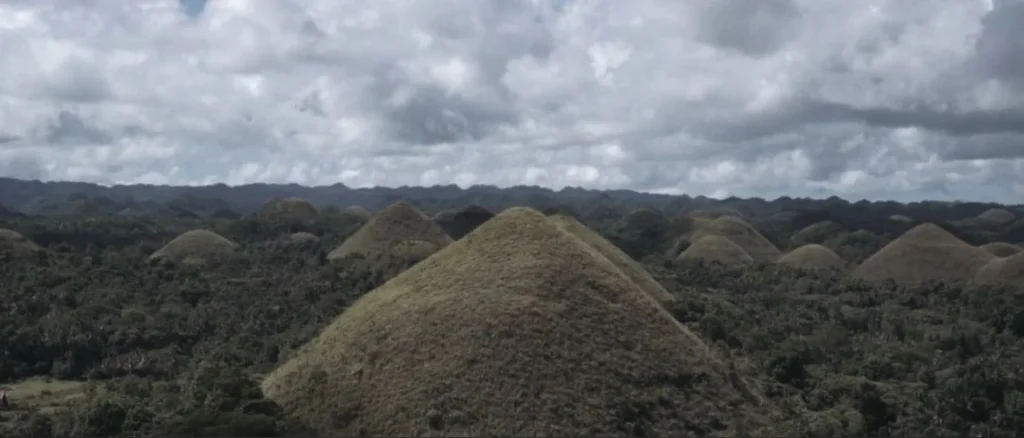
I’d seen photos of the Chocolate Hills before. Everyone has. They’re on the money — the 200-peso note, specifically. But photos don’t capture the scale.
These hills are 1,260 to 1,776, as one counts them. These are all over 50 square kilometers of central Bohol, very nearly uniform in shape, and grass-covered, growing brown on dry season. Hence the name. In the rainy season, they are green. I just missed them, middle-ground, brownish-gold, and it gave all the landscape the appearance of being on a different planet.
The geological explanation is weathering of the bedrock by the dissolving effect of rainwater, subsoil weathering. The neighborhood myth is more appealing: A giant called Arogo cried when a mortal woman that he loved passed away and his tears turned into hills. I prefer that one.
Stood at the viewpoint for a while. Overcast sky, no crowds that morning. Just those strange symmetrical mounds rolling toward the horizon.
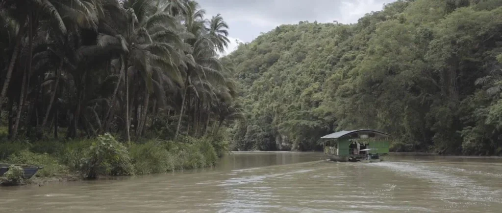
Same island, different experience: the Loboc River cruise.
“Cruise” is generous. It is a floating table with buffet and karaoke machine that is drifting slowly on a brown-green river surrounded by coconut palms and jungle. Sound tourist-y since it is. But this is the point it is not always there that the tourist thing has no reason. The river is beautiful. The vegetation is dense. And when you are riding by a village where children are backflipping off a bamboo sitting into the water to get tips, you no longer care about the measure of authenticity.
Loboc River is approximately 20 kilometers, which ultimately drains into the Bohol Sea. The floating restaurants have become a local industry. Cheesy? Sure. Worth doing once? Also yes.
The Bicol Region: Mayon near-perfect Cone and the Land around the Cone
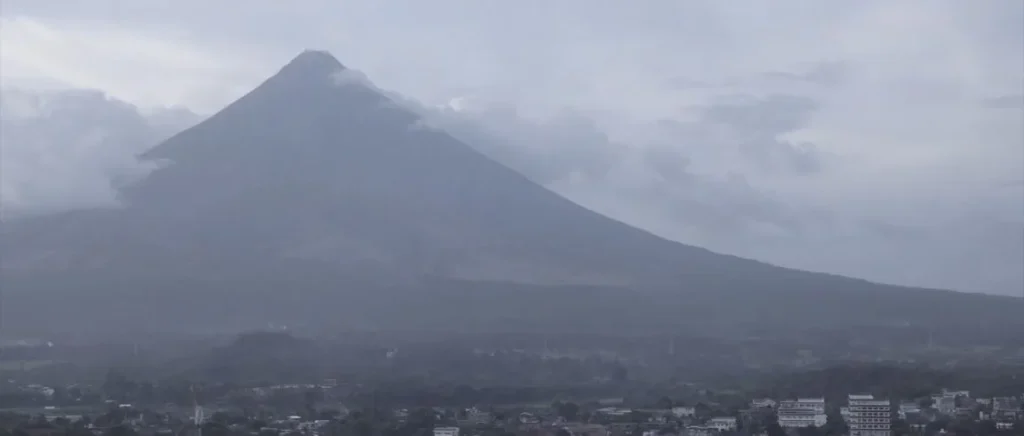
The cone of the Mayon Volcano is the most symmetrical among all volcanoes on earth. That is no exaggeration – it is what geologists do assert. The angle of slope is uniform throughout. According to some perspectives, it appears computer generated.
I had only two days in Albay province, so I was just chasing the scenes of this thing. The issue: Mayon is frequently covered with clouds. The mountain dictates its own weather. and you can wait hours and hours in expectation of the mountain showing itself, and it does not.
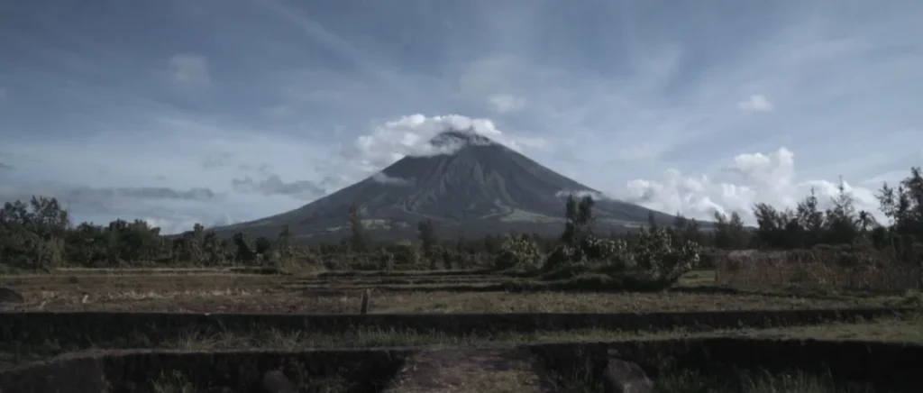
But when it does — even partially — you understand why people keep coming back here. I caught it from the farmland on the outskirts of Legazpi City, late afternoon. The cone emerging from haze, the town small at its base. The scale is disorienting. This thing has erupted over 50 times since 1616, most recently in 2018. People still live on its slopes. Farming continues. Life just… works around the volcano.
Mayon Quick Facts
- Elevation: 2,462 meters (8,077 ft).
- Last major eruption: 2018.
- Deadliest eruption: 1814, killed over 1,200 people and buried the town of Cagsawa.
- Status: Active (Alert Level varies).
- UNESCO status: Part of Albay Biosphere Reserve.
The Bicol area of Mayon is farmland – rice, coconut, abaca. All things are growing in the volcanic soil. The cuisine here is also different: it is full of chili (siling labuyo), coconut milk in all things. I also consumed large quantities of Bicol Express, which is pork cooked in shrimp paste and coconut cream that I ought not to admit.
Mount Pinatubo: 4x4s Over Lahar Fields to a Crater Lake
This was what I had been planning about in the trip.
The second-largest volcano eruption of the 20th century was the 1991 eruption of Mount Pinatubo. Expelled between 10 and 12 cubic kilometers of material. Sprinkled ash over the stratosphere. Reduced the world temperature by approximately 0.5C over twelve months. Displaced over 200,000 people. Lahar flows – volcanic materials coupled with rainwater – covered whole towns and changed the landscape several years later.
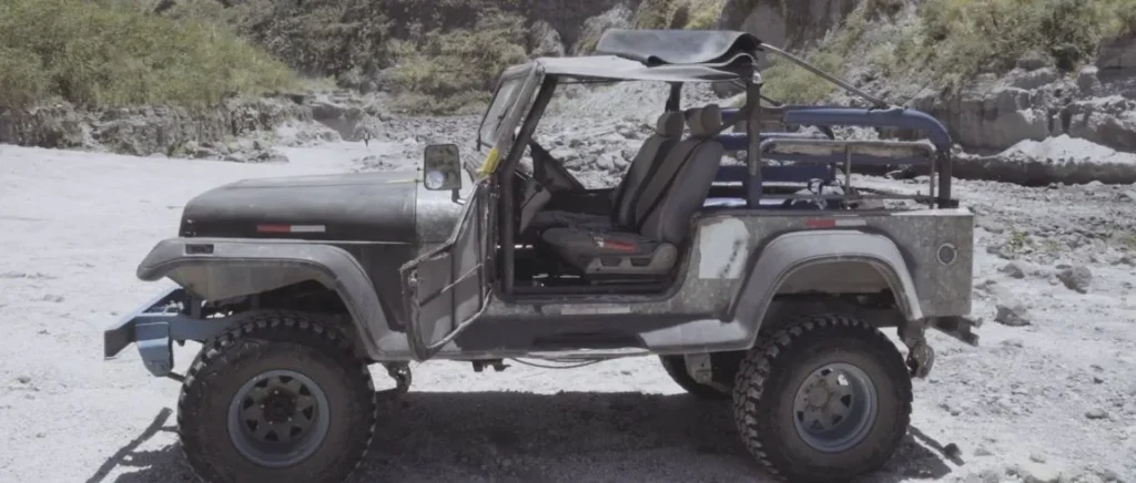
Today, thirty years later, you could travel over those lahar fields, in bare-boned 4x4s, to the crater.
Otherwise, the vehicles are different. They have old jeeps, gutted and modified, with cages welded on, their suspensions jacked higher, and anything that is not needed cut off. No doors. No roof on some of them. You pick up your driver in a holding ground at Capas, Tarlac, and you find yourself jumping on top of volcanic gray sand in some 45 minutes.
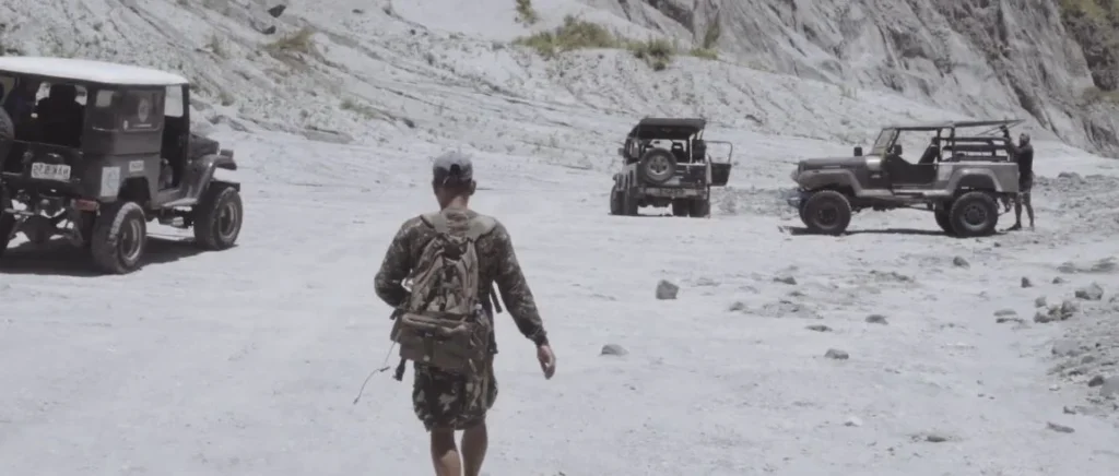
The terrain looks lunar. It is no exaggeration, literally it appears to be video footage of a landing on the moon. Sandy gray-white, boulders all over, bedrock of dry rivers. Part of it is slowly being restored by vegetation, and the lahar fields are generally barren. What transpired here becomes tangible with the size of it when you are passing through it in your car.
At a base point our convoy halted. From there, it’s a hike.
It is approximately 1.5-2 hours to the crater rim depending on your speed and the number of times you make a break taking a breath. It is not technical climbing, just a slow, more of an uphill scramble over loose volcanic rock, the crossing of a few rivers and a more serious climb towards the end.
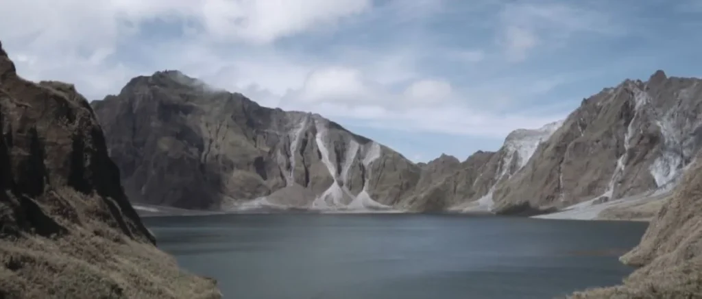
And then you see it.
The crater lake. This surreal blue-green water within jagged walls of rock and ash sat down in the crumpled caldera. The color changes with the light- it is turquoise at times and nearly gray at times. I arrived at the rim, and there was possibly half a dozen people there. Nobody talked much. We just stood and looked.
The lake didn’t exist before 1991. The caldera was formed when the eruption took place and was filled with seasonal rains during the years that followed. It is now approximately 800 meters in diameter and rather deep – the estimates are varied, though it has fallen much below the level it was around the beginning of the 2000s because the natural dam has worn away.
Pinatubo Trek: What to Know
| Detail | Info |
| Location | Zambales/Tarlac/Pampanga border |
| 4×4 ride duration | ~45 minutes each way |
| Hike distance | ~5 km to crater rim |
| Hike time | 1.5–2 hours up, 1–1.5 hours down |
| Difficulty | Moderate (some river crossings, loose terrain) |
| Best months | December–May (dry season) |
| Permit required | Yes, arranged through tour operators |
Worth considering: the trek is muddy and even non-passable during rainy season. The river crossings on the hike can rise rapidly. Timing matters here.
Into the Green: Trails of the Jungle and Kayaking through the Limestone
Not everything was volcanoes.
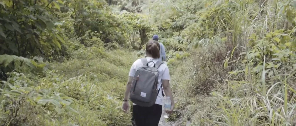
One morning–I really cannot tell which island now, the days were all the same–I found myself on a jungle path which was not mentioned in any itinerary. A local mentioned it. The opinion was whether you made a one-hour walk or not. “Easy,” he said. It wasn’t easy.
The path was overgrown. Ankles snatching at your vine. The dampness was so stifling that your shirt was wet in a ten-minute shower. I was along with one other traveler, a gentleman somewhere in Europe of whom I have no recollection of his name. We didn’t talk much. Pushing through the green, striking at objects, here and there pausing to see whether we were on the trail at all.
No viewpoint payoff. we had perhaps 40 minutes, and the trail led off into a thick brush, and we came back. Sometimes that’s how it goes. The jungle does not mind what you are planning to do.
The kayaking was different. Orchestrated, directed, totally worth it.
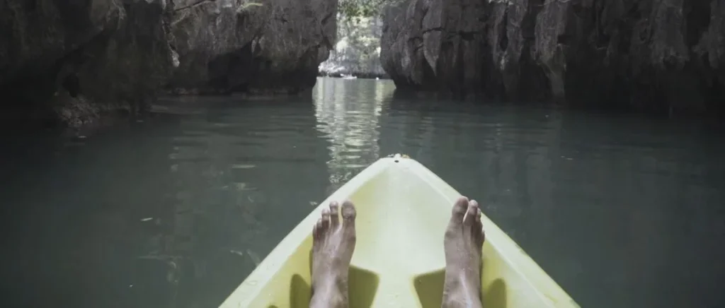
I had an afternoon of paddling between limestone karsts somewhere in Palawan, near Puerto Princesa, the Underground River region. The underground river itself is a UNESCO world heritage site; it is one of the longest underground rivers that are navigable in the world. But the environs lagoons and channels are nearly better. Less crowded. More freedom to explore.
The kayak point of view: horse feet on the bow, dark water under, limestone cliff on each side. Others of these structures are sharp, almost aggressive -millions of years of erosion have made spikes, jagged shapes that seem to be able to cut you, should you approach too closely.
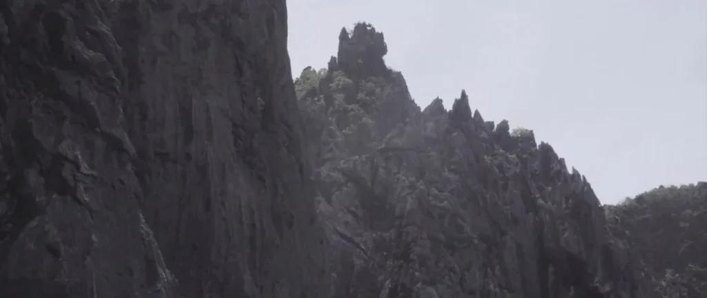
The karst terrain of Palawan belongs to a bigger geological aspect which spans Southeast Asia. Identical stuff in Ha Long Bay, Thailand in Phang Nga, a few feet of Indonesia. The coral reefs are ancient, which got uplifted since then eroded by slightly acids rainwater over tens of millions of years. The product is these unattainable towers and secret lagoons that do not seem quite real until you are sailing in them.
I rowed into a tiny enclosed lagoon – perhaps 50 meters in diameter, with cliffs on every side, and only one opening which the kayak just managed to squeeze through. Sat there for a while. Just water sounds and birds.
Nights out: Local Entertainment and Talking to people
Travel may be lonesome when it wants to be. You travel, take pictures, explore locations, but the human connection aspect is hard work.
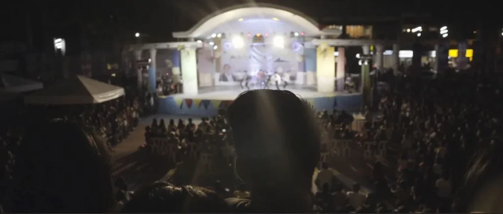
One night I was at some local fiesta. I do not even know what it was commemorating, patron saint day or a harvest celebration. A stage was placed in a town plaza, and lights were hung everywhere, families sat on plastic chairs, children were running about. A band played OPM hits (Original Pilipino Music is the home name) and some American hits of the 80s apparently known by everyone.
I was standing close to the rear of it. A male of an older age, who was sitting next me, began to talk. His English was superior to my Tagalog, which is not much. He enquired about my origin, what I was doing here, had I yet tried the lechon. Sent me to a stall that was selling it.
Lechon is whole roasted pig. Crispy skin, soft meat, with some areas having a liver-based or other areas using vinegar. The Visayas variant is not similar to the Luzon variant – Cebu lechon is filled with lemongrass and spices, whereas other locations leave it more basic. I ate too much. Went back for more. Zero regrets.
Things I Ate (Partial List)
- Lechon — roasted pig, crispy skin, life-changing.
- Bicol Express — pork in coconut milk and chili.
- Kare-kare — oxtail stew with peanut sauce.
- Sinigang — sour tamarind soup, usually with pork or shrimp.
- Halo-halo — shaved ice dessert with beans, jellies, leche flan, ube ice cream, everything.
- Balut — fertilized duck egg (tried it once, that’s enough).
Hospitality of Filipinos is a fact. People invite you to eat. They want to know your story. The fiestas are very much community based- they are not performed to entertain tourists, that is how life is in this area.
What I Would Have Done Differently (And What Succeeded)
Three weeks across multiple islands, and I still barely scratched it. The Philippines is massive, and island-hopping takes time. Ferries get delayed. Flights get canceled during typhoon season. Roads in rural areas are rough.
What Worked
- Flying into smaller regional airports when possible — avoids Manila traffic hell.
- Using local transport instead of private cars — cheaper, more interesting.
- Leaving buffer days between major destinations — delays happen.
- Dry season timing (December–May) — trails accessible, ferries running.
What I’d Change
- More time in Palawan — I rushed it.
- Skip Boracay — too crowded, too resort-heavy for my taste (though some people love it).
- Learn basic Tagalog phrases — even “magkano” (how much) helps.
- Bring more cash — ATMs are unreliable outside cities.
Budget Snapshot (Per Day, Solo Traveler)
| Category | Budget Range (USD) |
| Accommodation | $15–40 |
| Food | $10–20 |
| Transport | $10–30 (varies wildly) |
| Activities/entrance fees | $5–25 |
| Total | $40–115/day |
You can go cheaper — hostels, street food, public transport only. You can also spend way more. The Philippines accommodates both.
Final Thoughts: Why I’ll Go Back
The Philippines doesn’t try to be convenient. Flights get weird. Boats leave when they leave. The Wi-Fi dies. You sweat constantly.
But the volcanoes are active. It is the water of that shade of blue that does not exist elsewhere. The people really desire to communicate with you, not to sell something in particular. And gradually between a 4x 4 rattling through lahar lands and a kayak sailing through a limestone lagoon I ceased to worry about the inconveniences.
It’s not a trip for people who need everything to run smoothly. But if you’re okay with things being a little broken, a little chaotic, occasionally spectacular — there’s nothing quite like it.
I’ll be back. Probably Siargao next time. Or maybe back to Palawan to do it right.
We’ll see.